Monsanto, Blackwater, Pesticides, and Spies

Someone sent me a link to an interesting article about Blackwater, the well-known defense contracting firm in the Iraq war (now called Xe Services LLC). They’ve diversified into corporate Intelligence. Said The Nation article by Jeremy Scahill:

“Over the past several years, entities closely linked to the private security firm Blackwater have provided intelligence, training and security services to US and foreign governments as well as several multinational corporations, including Monsanto, Chevron, the Walt Disney Company, Royal Caribbean Cruise Lines and banking giants Deutsche Bank and Barclays, according to documents obtained by The Nation. Blackwater’s work for corporations and government agencies was contracted using two companies owned by Blackwater’s owner and founder, Erik Prince: Total Intelligence Solutions and the Terrorism Research Center (TRC).”

The person who sent it quoted a line from the article: “One of the most incendiary details in the documents is that Blackwater sought to become the “intel arm” of Monsanto, offering to provide operatives to infiltrate activist groups.”

I guess now we better watch for spies reporting our objections to Roundup in Sutro Forest discussions,” the sender adds, tongue in cheek.

NEUROTOXINS AND THE EPA

On a more somber note, someone also sent us a story from online publication Care2 about a $23.5 million jury award to the Ebling family whose childrens’ neurological health was destroyed by toxic pesticides. The pesticide was Diazinon, and in 1994, it was legal for household use. According to the article by Jessica Pieklo, the family lived in a treated apartment for a year, during which their small children developed neurological problems and had seizures. The family moved out as soon as they could, but it was too late. Their now 20-year old daughter has a developmental age of two years old; their son, not so badly affected, still “struggles academically and socially.” The Eblings, now divorced, sued the apartment owner and management company.

The Environmental Protection Agency did not ban the pesticide for household use until 2004 – ten years later. Clearly it either had inadequate information or it did not do enough to protect people.

Stories like this make us appreciate even more the pesticide-free space we have on Mount Sutro. UCSF tells us no herbicides have been used on the mountain since 2008; and none in the Aldea campus since September 2009. Thanks, UCSF. Let’s keep it that way.

Edited to Add:

GARLON IN THE GREENBELT

”]

We’ve just learned, unfortunately, that Rec & Park has no such compunctions about pesticides in the Interior Green Belt (managed by the Natural Areas Program). It’s using Garlon on the stumps of trees – presumably chopped down because they were hazardous. We don’t see the point of preventing resprouting here. Especially with toxic herbicides. This is near where the Mount Sutro Stewards plan to open a new trail through the Interior Green Belt, starting work on October 2, 2010.

Posted in Environment, Herbicides, Mt Sutro Cloud Forest, Neighborhood impact, UCSF | Tagged , , , , | 1 Comment

A Unique Forest

We’ve been convinced about the health and beauty of this amazing forest, but we’re not arborists. So we asked one to look at the forest for us. The letter below is from ISA-certified arborist, Jocelyn Cohen, who is a member of San Francisco’s Urban Forest Council; and Alma Hecht of Second Nature Design, also an arborist and landscape designer. (Hecht supports native plants, and Second Nature’s design philosophy includes restoration where appropriate.)

“Mt Sutro Forest represents a unique ecotype,” the letter starts, “perhaps the only one of its classification in the world. The 120 year-old hand-planted forest of now-naturalized eucalyptus trees and diverse understory species rising up on 80 acres of  San Francisco mountainside has developed many of the characteristics of a cloud forest at sea level.”

The letter also noted the factors confirming the forest’s health:

  • Lack of erosion
  • An average size range [of the trees] from small to monumental
  • Normal amounts of dead or fallen trees
  • Presence of diverse wildlife
  • Thick layers of undisturbed duff  feeding and sheltering critical mats of roots and beneficial mycorrhizal fungi

It also warns that disturbance from bicycles, hikers and heavy equipment could cause disruption of water flow patterns, and soil compaction. [At the UCSF community meetings, UCSF’s consulting forester Ray Moritz spoke of a “brontosaurus” – something like the machine below…]

Coming soon to Sutro Forest?

Posted in Environment, Neighborhood impact | Tagged , , , , | 2 Comments

One More Time: Fire Hazard? (FEMA notes UCSF’s inaccuracy)

Recently, we received a letter obtained by a public records request from FEMA (Federal Emergency Management Agency). UCSF had applied to this organization for pre-disaster mitigation funds to chop down trees on 14 acres of the forest, claiming the forest was a very severe fire hazard.

Dated October 1, 2009, the 5-page FEMA letter noted all the ways in which the UCSF application failed to substantiate an actual fire hazard – or show that cutting down trees and removing the understory would mitigate the hazard.

THOSE FIRE HAZARD MAPS – AGAIN

The letter pointed out that CalFire gives Mount Sutro a “moderate” fire hazard rating, which is its lowest rating. Meanwhile, the map in the application – the URS map from the CDF report (which claims CalFire as a source) – purports to give a “Very Severe Fire Hazard.”(We had a whole post devoted to this map confusion – which was further complicated by the addition of two other maps…)

FEMA actually talked with CalFire about the discrepancy. Their conclusion:

  1. “UCSF inaccurately interprets” the map. (I.e, they’re not getting it right.)
  2. “…the map cannot be used to identify the hazard.” (I.e, it doesn’t show fire hazard.)
  3. The CalFire map “more aptly characterizes the actual wildfire hazard…” (I.e. the CalFire map is the one to use.)

At the July 2010 community meeting, we were surprised to see UCSF again present the very same map that was contradicted by CalFire – even though we wrote about the discrepancy in October 2009,  and FEMA did so in more detail in its letter.

FELLING TREES – CREATING A FIRE RISK?

We’ve been concerned that “thinning” the trees will actually create a fire hazard where there is little now. Evidently, we were not the only ones. FEMA asks UCSF to show that a drier forest and changes in wind patterns “would not result in an increase in the wildfire hazard in Sutro Forest.”

GOOD FAITH?

It’s been pointed out to UCSF that maintaining a claim that there’s a very severe fire hazard, in the face of expert evidence to the contrary, is not only misguided , but could adversely impact neighbors: It’s frightening; it could cause insurance concerns; and it could become a disclosure issue if property sales are planned.

UCSF continues to claim the fire risk is high, despite clear evidence that this is mistaken, and that these claims – even if  in error – can impact the neighbors. It continues with its plans for thinning the forest despite the potential increase in the fire hazard.

It is this sort of thing that calls into question whether UCSF is actually acting in good faith.

Posted in Meetings, Sutro Forest "Fire Risk" | Tagged , , , , , | 3 Comments

Tree Lovers vs Nativists: Matt Smith in the SF Weekly

Matt Smith’s new column in the SF Weekly clearly indicates the battle lines for Mount Sutro’s forest: The Nativists, who want to “thin” the eucalyptus to plant native plants instead; and Neighbors and friends of the forest, who want to preserve this mysterious wild cloud forest in our midst.

Smith comes down strongly on the side of the nativists, (represented by Craig Dawson and Jake Sigg of the Mount Sutro Stewards). This volunteer group maintains the trails in the forest, and also the Native Garden on its summit. We don’t have a problem with that; Smith is as entitled to his views as we to ours; and we value the Stewards’ trail work.

WHERE WE DISAGREE

Here’s where we disagree. He considers the Stewards’ plans:

“They plan to thin branches, bushes, and vines from a few small patches of the forest in hopes of eventually restoring some of the primitive fescue that covered the hill before the tree-loving Sutro began his late-19th-century planting binge.” Elsewhere in the article, he refers to it as “modest tree and brush thinning.”

Not quite. The plan, as it currently stands is as follows:

In the Demonstration Phase:

  • Cut down around 3,000 – 5,000 trees on about 7.5 acres of land, leaving the trees spaced an average of 30 feet apart. That would be around 40-50 trees per acre. (They average 740 trees per acre now, so around 700 trees per acre would be felled.)
  • Mow down the understory in these areas. This understory, consisting of blackberry, acacia and ivy among other plants, is habitat for birds, insects and animals. It also helps the forest to retain moisture so it is always damp.
  • Use the toxic herbicides Roundup/ Garlon to prevent regrowth of eucalyptus and blackberry.

In the Followup Phase:

  • Extend the same 30-foot spacing to another 40 acres of the 61-acre forest. This would mean cutting down another 25-30,000 trees.
  • Mow down the understory of the forest on this area as well, further reducing habitat.
  • Build two new trails, including one from Clarendon Avenue through a screen of trees that is already heavily thinned by a water-pipe project.

The idea is to achieve a “park-like” environment, with a sparse canopy and sunlight reaching the forest floor.  (The word park-like is taken from documents shown at the community meetings. The “sparse canopy” is also a direct quote.)

The felling of thousands of trees, considerable habitat destruction, and the use of herbicides on high ground doesn’t strike us as “modest.”

FIGHTING FOR MOTHER NATURE

Smith puts this battle in the context of a broader issue: What he describes as San Francisco’s willingness to support the environment but “fighting measures that have the actual direct effect of restoring or preserving Mother Nature.”

The issue here is clearly one of definition. The nativist philosophy is that “Mother Nature” is represented only by Native flora and fauna. Our philosophy is that Nature includes all things natural – all plants and animals and ecosystems. So yes, as believers in the environment we support preserving the forest as it has naturalized on the mountain. We consider a blackberry thicket growing wild, full of berries and birds,  to be as natural as a carefully-tended patch of gumplant in the Native Garden. We fight to preserve Mother Nature manifest in a naturalized forest.

Smith says: “I, too, am fond of eucalyptus groves at Mount Sutro and Mount Davidson, and the way they’re so thick as to create the illusion of wilderness isolation to hikers within. But I also love the spots in the city still covered in millennia-old fescue ecosystems, where 50 different plant species may reside in an area the size of a backyard.

So are we, and we think there’s room for both. That’s why we think that preserving Mount Sutro’s cloud forest, taken in the context of the whole city, actually increases biodiversity.

The article also discusses landslides, using Jake Sigg’s argument that the trees increase the danger because of their weight. In fact, the root system of these trees, inter-grafted into a solid root mat over the mountain, prevents landslides. Removing trees will increase the landslide risk. There have been landslides in this neighborhood, always in conjunction with tree removal or slope disturbance.

A CENTURY OLD, A CENTURY YOUNG

Smith repeats the allegation that the forest is dying and cannot re-seed. This belief is erroneous. Eucalyptus in wet conditions has a life span of 200-400 years.  Also, eucalyptus regenerates from lignotubers. Like redwoods, it can grow by sending out new stems from existing root systems. The forest does not need to re-seed to renew itself.

Left alone, these century-old trees will be around for many lifetimes.

Left alone, San Francisco’s beautiful mountain will continue to provide a unique wild cloud forest experience in the heart of one of the world’s great cities. We hope Smith (and the daughters he mentions in his article) continues to enjoy it as much as we do.

Posted in eucalyptus, Herbicides: Roundup, Garlon, Mt Sutro Cloud Forest, Mt Sutro landslide risk, nativism, Neighborhood impact | Tagged , , , , , | 1 Comment

Hiking in Mount Sutro Forest – Pointers and Map

We’ve been talking about the beauty of this forest, especially on a foggy day – and it occurred to us that hikers less familiar with it might want better information. This article has been reprinted from Mount Sutro Forest.

[Edited to Add: We also suggest looking through recent our posts (listed on the right side of the Home Page)for reports on trail hikes. We try to report on hiking conditions from time to time.]

—————————————————–

Hiking in Mount Sutro Forest is a different experience than almost anywhere else in San Francisco. It’s heavily shaded under the tall trees. Looking up at the trees, some of which are 100-200 feet high, really gives a sense of being in an old, wonderful place. On a foggy day, it may be the most beautiful place in all the city. The mist wraps the tops of the trees towering overhead while you walk through the trails of a fresh wet forest in its self-contained rain. On weekdays, there are usually few people around, so there’s a sense of splendid isolation amid towering misty trees.

Though we love best the days when it’s a mysterious cloud forest, sunny days are also delightful in the woods.

GETTING THERE

Mount Sutro is on the western side of San Francisco (see the front page of this website for the location). It’s north of Clarendon Avenue, South of Parnassus Avenue. It’s accessible by public transport, though it’s a bit of a walk in from the nearest bus-stops.

Edited to add this May 2014 information about the bus. It’s from Tony Holiday, who should know:

For locals who take MUNI, the #43 goes up Parnassus and stops:

  • At Willard (for the Farnsworth stairs), in front of the hospital buildings at Medical Center Way (take the stairs behind the buildings), or
  • At 7th Ave. across from Garden for the Environment if you want to take the Oakhurst stairway up from Warren [through the Forest Knolls neighborhood] – this is a more vigorous trek though.
  • Or get off at Stanyan, same bus, and uphill it to 17th & the upper Stanyan trailhead.

All from one bus!

PARKING IS LIMITED

There’s no parking area for the forest; all the parking lots in and around it are for UCSF employees or students. So it’s street parking. Here are the options:

1. Stanyan and 17th. The trailhead starts with a wooden staircase about two houses above the intersection. The area has 2-hour street parking.

2. Clarendon Avenue. This will give access through the Aldea campus to the Fairy Gates Trail or the East Ridge Trail.  There’s also a new trail starting at the top of Behr Avenue, on your left just before the chain blocking the Nike Road.  (If you park on Clarendon Avenue, be careful to conceal belongings; a number of cars have been broken into.)

3. Christopher or Crestmont. You can usually find unlimited street parking in the neighborhood; the unmarked trailheads start opposite 101 Christopher and 365 Crestmont. These are steep. [Edited to add March 2017: The unmarked trail head opposite 101 Christopher Drive has been closed. There’s a new trail that starts next to the pumphouse at Christopher and Forest Knolls Drive; it’s longer and more gradual. We will update the map soon.]

4. Edgewood. There’s usually neighborhood street parking somewhere there, and you can access the trailhead at the end of the road.

5. Belgrave. Neighborhood street parking with limited hours. This trail is quite dense; it brings you to the Aldea campus where you can take various other trails.

MAPS AND TRAILS

A number of trails go into the woods, from various points around the mountain. Carry a trail map with you, at present there are no maps at the site, though trail markers have recently been added (2010).

[Edited to Add (July 2, 2011): The map below is based on one from OpenStreetMap.org, with some added trails, boundaries and labels. If you click on it, then click again, it opens up to a larger version that can be printed. ETA Jan 2012: Updated to add a new trail and also add the original name of the Fairy Gates trail, “Topo Trail.” . ETA March 2017:  The unmarked trail head opposite 101 Christopher Drive has been closed. There’s a new trail that starts next to the pumphouse at Christopher and Forest Knolls Drive; it’s longer and more gradual. We will update the map soon.]

The Google map’s embedded here to give a sense of the steepness of the slopes:

There’s a more detailed Sutro Forest trail map (as a PDF) here at Pease Press Cartography.

If you are looking for the ethereal cloud-forest experience, pick a foggy day in summer, and go for trails such as the South Ridge Trail, and the top part of the Historic Trail. As a general rule, look for areas where the undergrowth remains dense and the tree canopy exists. Narrower trails (the fainter lines in the map above) are more atmospheric.

The lower part of the Historic trail is quite dry especially around the area where it changes direction from North to West (going downhill). The Fairy Gates Trail, which runs below Medical Center Way past the Chancellor’s house, is one of the driest – it is often dusty even in foggy weather.

ENTERING THE FOREST

From the Clarendon Avenue side, trails start within the Forest Knolls neighborhood (street parking) and UCSF’s Aldea Student Housing (no outsider parking).

From Aldea:

  • The Fairy Gates trail starts just outside the Chancellor’s house on Johnstone.
  • The East Ridge Trail starts opposite the new community center (under construction) further up on Johnstone.
  • The paved Nike Road leads up to the Rotary Meadow and Native Garden (a flat open area, at its best in spring), and various trails lead off it. A new trail has just been built starting to the left of the Nike Road, just below the chain that blocks cars from going through. (November 2011)

From Forest Knolls, two trails offer a steep climb up to a cloud-forest environment.

  • The South Ridge trail opposite 101 Christopher. [Edited to add March 2017: The unmarked trail head opposite 101 Christopher Drive has been closed. There’s a new trail that starts next to the pumphouse at Christopher and Forest Knolls Drive; it’s longer and more gradual. We will update the map soon.]
  • The West Ridge trail opposite 365 Crestmont.

Medical Center Way, the paved road joining the Aldea campus to Parnassus Avenue intersects a number of trails.

  • The Historic trail (goes up toward the summit)
  • The North Ridge trail (also rises toward the summit)

On the downhill side:

  • The other end of the Fairy Gates trail, which winds around the hillside to the Aldea campus;
  • The top end of the Edgewood trail, which will take you down to Edgewood;
  • The top end of the Stanyan “Kill Trees” trail will take you down to Stanyan;

If you’re starting at Parnassus, you can also climb the steps from the bottom of Medical Center Way to the Surge Parking lot.

From Edgewood Avenue/ Farnsworth/ Belgrave/ Stanyan

  • There’s an unnamed and rather unexciting trail starting on Farnsworth (very limited street parking), at the north end of Edgewood, going through the Surge parking lot. Mainly, it will get you to Medical Center Way.
  • At the south end of Edgewood (street parking), the lovely-but-steep Woodland Canyon trail (alias the Edgewood Trail) connects to Medical Center Way and to Fairy Gates. There’s a seasonal stream that you can sometimes hear in winter running below. [ETA2: From here, the dead trees on the “Kill-Trees Trail” are also visible. This trail is planned to be opened some time in Spring June 2011, and will give access from Stanyan. We will update this when it’s opened.] [ETA3 – June 2011]: The trail connecting Stanyan to Medical Center Way is open. It starts with a wooden staircase just above Stanyan and 17th, and climbs up toward Medical Center Way, connecting to the Fairy Gates Trail. This new trail is broad and easily accessible to bike-riders.]
  • From Belgrave (2-hour limited street parking), there’s an access point at the western end of Belgrave. It takes you into the Aldea campus. [ETA June 2011: This is a relatively narrow and wild trail. Another trail forks right; it is quite wild and would appeal to the adventurous who don’t mind ducking under low-hanging trees or moving aside thorny blackberry sprays. It doesn’t connect to anything right now, but does provide a less tame forest experience. It connects – sort of – to the Kill-trees Trail. Definitely a non-tame forest experience; Here’s an account from August 2012 (read the Wild Trail section).]

CAVEATS AND BEING PREPARED

Waterproof shoes. It’s almost always damp in there, even on a sunny day. This is a Cloud Forest, and it lies in the Fog Belt. Even if it’s sunny downtown, or outside the city, it may be misty in the forest. Or it may have been cloudy overnight, with the forest’s internal rain falling through the night.

On a foggy day, slush on the trails is normal and unavoidable. Wear shoes that can cope. There aren’t many puddles, even on a foggy day, but some of the trails get very wet and muddy indeed. However, the trails vary greatly in how wet they are. The Stanyan “Kill-trees” Trail is quite dry even on a foggy day, as is the Fairy Gates Trail.

(Update mid-Jan 2014: With our very dry winter this year, there’s no mud. Most of the trails are very dry and may be slippery due to gravel and dust – especially for bicycle riders. A few areas are damp, which is ideal.)

(Update Aug 2011: The South Ridge trail is particularly boggy in very cloudy weather. If you’re not wearing mud-proof boots with good treads, we’d recommend using a different route.)

(Update 2010: Some trails are now so wide with undergrowth removal that they can be dry, even dusty. In this condition, on sunny days they become slippery from dust, dry leaves, and gravel, particularly on slopes.)

Long pants and long-sleeved clothes. It’s seldom warm enough to be comfortable in short-sleeved clothing. It also helps against poison oak. On foggy days, dress warm and wear rain-gear. Even if it’s dry outside, it will be raining in some areas of the forest.

Allow for mud. If it’s a foggy day, clothes can get muddy. Especially if you kneel down to get photos like the one above.

Stay on the trails. This protects both the forest, and the hiker. Poison oak is an issue. Though not as rampant as in more sunny areas, it is also more difficult to spot amid the greenery.

Careful on wild trails. In addition to the named trails shown on the map above, there are a few “wild” trails that are maintained little, if at all, and may dead-end into impassible greenery. They aren’t suitable for bike riders, but for someone interested in a wilder experience, these may be interesting to explore. Caution: some of them will have poison oak.

Careful on very stormy days. Many times, when it’s windy on the bare hills like Twin Peaks, there’s not much of a wind in the forest; the trees block it. But if it’s stormy, there could be falling branches – especially in more open areas of the forest and along the edges.

If you lose something or find something valuable, the UCSF Police are at 415-476-1414

ACCESS ON THE TRAILS

Some trails are also accessible to mountain-bikes. (Motorized bikes are not allowed in the forest.) Volunteers at SF Urban Riders help to maintain the trails. The best trails for riding are the Historic Trail and the Fairy Gates trails, others may be too muddy for comfort in foggy weather. (There’s an article here about accessing the Forest from the Forest Knolls neighborhood.)

The trails are suitable for older kids, not so much for very little ones who may want to be carried. Some trails – especially Fairy Gates – have steep edges and drops. There’s no stroller or wheelchair access except the paved Nike Road up to the Native Garden (the garden itself has gravel paths, not paved ones).

Dogs are allowed, though they’re supposed to be leashed. (A plea to dog-people: Please don’t leave plastic baggies of droppings in the forest, they don’t biodegrade even if they’re meant to. They uglify it for everyone else.)

[Edited to Add: What happened to the map that used to be here?  Though we believe it to be non-copyright, we took it down because of a letter from the lawyers for Sutro Stewards. We  hope to replace it soon so you can actually see what we’re talking about when we mention trail-names below.]

Posted in Maps, Mt Sutro Cloud Forest | Tagged , , , | 14 Comments

Wind. Fog. Mount Sutro Forest

The wind was strong this afternoon, blowing over trashcans, swishing the tops of the eucalyptus like great lace fans, swirling the fog into romantic curls. The sun was AWOL.

A perfect day for a walk in San Francisco’s own cloud forest.

Inside the forest, the wind was much weaker; indeed, in many places, it was almost still at ground level, though the trees swished and creaked and there was an occasional groan or crack overhead.

It felt safer inside the forest, especially where the trees were dense; not only was the wind less strong, but if a tree should go over, its chances of hitting the ground were small. It would lodge in other trees.

The tops of the tallest trees were almost lost in the fog. The sub-canopy of smaller trees was more immediate. A squirrel darted up this tree, but vanished before it could be caught on camera.

The trees always look splendid, but in the fog, they are especially beautiful. The soft gray light reflects off the wet bark. The moisture harvested from the fog falls like rain.

The Rotary Meadow has no fog-harvesting trees, and the meadow loses moisture quickly. The grass and the gravel there was dry. The season’s  over, though a few Coastal Gumweeds (grindelia hirsutula var. maritima) still bloom. Most of the shrubs are still green. The oak trees are ok.

The more exposed areas of the “Fairy Gates” trail were also dry, with dust in places deep enough to show footprints. But in the ravine below, the trees and foliage was still lush and green.

Some blackberry bushes bore ripe fruit. We ate several, confident they contained no Roundup or Garlon (thanks for the pesticide-free mountain, UCSF!), and felt no guilt about stealing from the birds. There was enough.

Speaking of birds – on a foggy day like this one, they were quiet. But a few juncos hopped around in the trees and undergrowth; and a hairy woodpecker flew from acacia to eucalyptus. It refused to pose.

Posted in eucalyptus, Herbicides: Roundup, Garlon, Mt Sutro Cloud Forest | Tagged , , , | 3 Comments

A Tree House Dream

UCSF’s building a new community center in the Aldea Student Housing area. There’s nothing especially wrong with the building, a practical-looking structure that’s going where a student residence used to be. [ETA Aug 2011: Here’s a picture of the completed building.]

But someone sent us this picture, and we indulged in a little wishful thinking: Wouldn’t have it been gorgeous to have something like this instead? (Yes, we know we’re dreaming.)

It’s a tree-house in Oregon, built by Robert Harvey Oshatz as a family home. Here’s the link to the article on his website. It has a lot more photographs.

Posted in UCSF | Tagged , | 1 Comment

3 Reasons Not to Use Roundup

Someone sent us a link to an article about Roundup by Caroline Cox, a scientist who leads the pesticide research at Center for Environmental Health.

Titled “Why You Shouldn’t Use Roundup (Or Trust Its Labels),” it’s one of the most accessible articles about why it’s not a good idea to use Roundup. It’s also well documented, with links to the research papers it cites.

Here’s a summary:

1. The label calls it fast and easy. That’s true, it’s a powerful herbicide. But often, all it does is leave an open niche that will promptly be colonized by other plants. (There’s evidence elsewhere that some plants are developing a resistance to Roundup.)

2. The company claims Roundup works by targeting an enzyme found only in plants. Maybe. But it’s a mutagen, causes abnormalities in the fetuses of pregnant rats, and considerably interferes with production of sex hormones in human cells (reductions of up to 90%).

3. The label claims it breaks down without moving into the soil. If so, we’re not sure where all the Roundup in the water is coming from.  A study of 10 streams compared water upstream and downstream of waste-water treatment plants. The downstream water had twice as much glyphosate (the “active” ingredient in Roundup, though the “inert” ingredients are not so inert, actually) and its breakdown products as the water upstream.

The article continues into a good presentation against the use of herbicides.

Garlon 4 Ultra, Twin Peaks

To UCSF’s credit, no herbicides have been used on Mt Sutro since 2008, and in the Aldea Student Housing since late 2009.

Imazapyr, Stern Grove

It may be the only herbicide-free wildland in the city. (The sadly-misnamed “Natural Areas Program” uses Garlon and Roundup on Twin Peaks and Mt Davidson, and Imazapyr at Stern Grove.)

But this will change if the “plan” for the forest goes through. Roundup (or Garlon, which may even be worse) is what UCSF plans to use on shrubs and trees on the slope above Forest Knolls — and potentially,  in more than half the forest.

Posted in Herbicides, Herbicides: Roundup, Garlon, Mt Sutro Cloud Forest, UCSF | Tagged | Comments Off on 3 Reasons Not to Use Roundup

Coyote Careful

We don’t know if there are coyotes in Mount Sutro Forest, but we do know they’ve been seen in Golden Gate Park and Glen Canyon and Twin Peaks and Midtown Terrace. Since they can hunt over 4 km, it’s possible that they’re around.

So as a public service announcement we’re linking to a blog post about “aggressive coyotes” from Janet Kessler, the Jane Goodall of San Francisco’s coyotes. She also has a whole page on coyote safety. And if you’re generally interested in our city’s coyotes, her Coyote Yipps blog has hundreds of pictures and observations.

The main issue with coyotes isn’t humans. They’re shy of people unless someone has been feeding them, which is a Bad Idea. It’s dogs.

Dogs and coyotes are from the same family, which means that coyotes are very aware of dogs as potential threats, potential allies, or even potential mates. And dogs are often quite aware of coyotes, and may chase them.

If an unleashed dog chases a coyote, sometimes it’s a game and sometimes it is not. If the coyote feels threatened, especially if it’s near a den, especially if there are pups involved – it might attack. The solution is to keep dogs on leashes when walking in coyote territory. And maybe carry a shake-can (a small juice-can rattle with rocks and coins in it).

It keeps everyone safer. The dog. The coyote. The pups, if any. And the people involved.

Posted in Neighborhood impact, Uncategorized | Tagged , | 2 Comments

Ishi’s Shrine

There’s a story that Ishi, the last of the Yahi tribe of Yana native Americans used to wander Mount Sutro Forest in the early part of the century.

His tribe was massacred, and having nowhere to go, he wandered into the world of the white stranger. Taken into protective custody, he was studied by UC researchers, and lived at UCSF’s campus (which then  housed UC Berkeley’s Museum of Anthropology).

The story that he frequented the forest is unverified, and perhaps unverifiable, but along one of the trails in the forest, there’s a low, shallow “cave” – hardly more then a depression in the rock. Here, someone has fashioned a little shrine to Ishi. It’s been there a while, but the original picture had faded, and was removed.

Ishi in 1914

Today, someone had renewed the shrine with a fresh picture, and put a quarter as an offering, a Connecticut quarter with a tree on it. “How appropriate,” said my companion, carefully placing a eucalyptus leaf in the shrine, “I always offer something when I come this way. A fragrant leaf, or something.”

[ETA on 29 Sept 2010:  We passed by that way today; the shrine was gone, though someone had still left a green leaf on the rock shelf where the picture of Ishi was before. Wonder what happened. Did the Mount Sutro Stewards decide against it? Did a random passer-by steal the picture? We don’t know.]

Posted in Mt Sutro Cloud Forest, UCSF | Tagged , | 4 Comments

Admin stuff, and Thank You

It’s been over a year since this website was started up and it has a new look. The template we were using became obsolescent, and we wanted one that was easier to read and better for pictures. So here we are, and we hope you like it!

And we’d like to take this opportunity to thank our readers for being there.

SEEING DOUBLE
You may have noticed, if you’re subscribed to the website, that the posts you get in your inbox aren’t identical to the one you see at the actual website. (Sometimes they’re very different.) That’s the result, usually, of a premature publication followed by an Oops! We’d recommend clicking on the link to get to the actual post rather than reading it in email.

POLICY ON COMMENTS
Those following this website may also have noticed we’re editing comments a bit more extensively. We much prefer not to, and before this, most of our edits have merely been to remove personal comments or actual names.

Lately, we’ve had a large number of comments from people who disagree with us. We appreciate their stopping by to comment – this website is open to opposing viewpoints. But we do try to avoid flames, and once something has been repeated 2-3 times, we don’t think there’s much value-add for our reader in making the same point.

A small amount of snarkiness on a website is okay; too much becomes annoying for anyone not actively involved in the battle. So faced with the choice of allowing the tone of the discussion to slide into the usual internet flame-wars, refusing the comments altogether, or editing them, we went with what seemed like the least-bad option. We’ve tried to be respectful in the edits, removing personal remarks while retaining the substance of the comment.

We continue to welcome comments, from supporters, opponents, or onlookers. But the medium does impose restrictions. Lengthy comments become tough to read, especially as threaded responses. Ideally, keep it short – and one topic at a time is best.

And please, let’s keep it civil. We don’t do flame-wars. We won’t post flames, spam, or comments which repeat something that’s already been said many times over. [Edited to Add: We also delete expletives. We want to stay family-friendly in case of child readers.]

To all who comment: thanks for taking the time and for expressing your views.

Posted in Uncategorized | 2 Comments

Endangered Butterflies

A commenter on this website, ‘Jonathan’, suggested that a good reason to destroy the Mount Sutro Cloud Forest would be to bring back habitat for endangered butterflies. Besides the Mission Blue Butterfly (for which there’s an attempted reintroduction on Twin Peaks) he suggested three others: The San Bruno Elfin, a tiny brown butterfly (pictured); the Callippe Silverspot; and the Bay Checkerspot. These are all butterfly subspecies found on nearby San Bruno mountain, which has some 2700 acres of preserved habitat. (A subspecies is what it sounds like: a division below the “species” level. Subspecies of animals or insects can often interbreed, but don’t usually because of geographic isolation.)

So we thought we’d look into it, (though we’d consider the destruction of this unique and beautiful forest a very high price to pay). The answer, as one might expect, is complicated.

According to a 2001 article by Sherri Graves and UC Davis’s Professor Art Shapiro, some 82 of California’s 236 butterfly species are already known to use introduced plants for feeding and/ or breeding. This can allow a species to expand its range or its breeding period, making it more successful. One example is the Anise Swallowtail, which now breeds on non-native fennel. Another is the Monarch butterfly, which uses the eucalyptus that has replaced all the other tall trees that were felled for lumber or land. [ETA: In a 2002 paper, Prof. Shapiro notes that around Davis – perhaps the most intensively studied butterfly habitat in the US – 29 of the 32 species breed at least partly on introduced plants. And 13 don’t seem to have a native host plant at all.]

Because insects have short life-cycles, they often can adapt to changed vegetation, and more may be in the process. For instance, some butterflies may lay their eggs on plants that poison their larvae. If there’s enough genetic variation in the population, a few larvae might actually survive. If they pass on their immunity to their offspring, they have another plant to use.

So what about these endangered butterflies? It turns out that at least at present, they all breed on very few plant species. Their caterpillars are picky. (We can also speculate that perhaps there’s not be enough variation within their diminished populations for them to adapt to other plants, though of course we don’t know this.) The Mission Blue breeds on a few species of lupine. The San Bruno Elfin needs broadleaf stone-crop. And the Calippe Silverspot (Speyeria callippe callippe, an endangered subspecies that shades into Callippe Comstocki to the south, and Callipe Liliana up in Marin)  uses the yellow pansy as baby food.

Mission Blue larva + ant

Then there are the ants as nurses. Some species (the Mission Blue and the Callippe Silverspot, don’t know about the others [ETA: Also true of the San Bruno Elfin]) need native ant species to nurture their caterpillars. The ants, attracted by “honeydew” – a sugary caterpillar pee, protect caterpillars from enemies. Even on San Bruno Mountain, the relatively warm eastern side has native ant populations; the windy foggy western side has mainly Argentine ants. Mount Sutro, which is windy and foggy on all sides (because of the way the fog belt works) is unlikely to be a warm safe place for ants. [ETA: Argentine ants do apparently tend caterpillars, though it’s not known how effectively they defend them.]

So restoring butterfly habitat isn’t as simple as “if you plant it, they will come.” According to a 2007 report on San Bruno mountain – where the battle is to preserve habitat from housing development – there have been no instances of successful butterfly habitat restoration in 25 years: “The process of destruction, mitigation, and restoration does not address the site specific ecology of butterfly species, and the complexity of these grassland systems. It is entirely without scientific merit. The survival of these butterflies is not as simple as the farming of host plants, or the mass rearing of larvae (Matoon et al 1971). To replicate the system would require its associated group of organisms to all be present. To the best of my knowledge, no new Mission Blue nor Callippe Silverspot areas have been established by humans in the past twenty five years…”

Finally: These are grassland species, growing in flammable spaces. Pansies apparently need occasional fires to burn off competing plants. The lupines grow best in disturbed ground, where it’s burned or there’s been a landslide. Fire may be part of the ecological cycle that keeps their host plants healthy.

San Bruno Mountain’s had a bunch of fires. A prescribed burn in 2003 got out of control and burned over 70 acres. In August 2006, a 50-acre fire was put out with helicopter assistance. May 2008, a 7-acre grass fire was contained after it went to three alarms. Then in June 2008, a five-alarm fire burned 300 acres and threatened homes.

It’s bad enough in San Bruno, but that has 3,000 acres of open space.  Mount Sutro Forest is 80 acres, surrounded by homes and a hospital. Converting it to a fire-prone ecology is a bad idea.

Posted in Environment | Tagged , , , , , | 14 Comments

Mount Sutro Forest: A Walk in the Fog

Summertime, and San Francisco is cool and misty, and this summer even more so than usual.  It’s a wonderful time to visit the forest, which is right inside the fog belt. In foggy weather, Mount Sutro Cloud Forest may be the most beautiful place to visit in all of San Francisco. We’ve been up there a couple of times recently when the world outside was wrapped in a soft grayish haze.

It felt like stepping through a magic portal into another world. Inside the forest the air was clear, it rained lightly, and  we squelched along trails in areas where the undergrowth was still dense and hadn’t been thinned.  Above us, the trees towered into the fog. It was quiet, except for the sound of the water dropping on the leaves. Birds don’t sing much in this weather,  but the occasional chirp or whistle let us know they were around. They say fog can muffle sound, and perhaps it’s true. Even less city noise filtered in than usual.

Vandals had been at work in one place: saplings had been torn down by force to attempt to block a trail. We weren’t sure why; if perhaps it was someone who objected to bikers, objected to trails, or perhaps shared some kinship with the tree-killer of Golden Gate park.

But even that couldn’t detract from the serenity of the forest, the soft wind in the trees, the filtered light.

WHERE IT’S DRY

As we followed the historic trail down from the summit, just after the junction with the Western trail, it opened into an area where the trees and undergrowth have been cut back. Here, the trail was dry. Instead of mud, there was dust and dry leaves.  Then we were under the trees again, and again the forest held in the moisture.

We crossed Medical Center Way (the main paved road through the woods), and found our way to the Fairy Gates Trail. (There are trail markers at all intersections now.) The end near Medical Center Way has been realigned recently, and still looks like a construction project, all bare earth and no vegetation. This trail, which runs by the house of the UCSF Chancellor, has hardly any canopy or understory and is very dry.

The forest was in the ravine below; along the trail, nasturtiums bloomed with enthusiasm. “The young flowers are great in salads,” someone said.

Posted in Mt Sutro Cloud Forest, UCSF | Tagged , , , , , , , | Comments Off on Mount Sutro Forest: A Walk in the Fog

Native Plants, Chaparral: Conversation with ‘Charlie’

From time to time, people come by to comment and engage with the information on this website. We appreciate that. ‘Charlie’ commented on several posts, but this comment was long and complex enough that it deserved a separate post.

*******************

Charlie: Hmm, well as someone who is not part of your group, the way you are tossing around ‘nativist’ was a big put-off.

‘Nativist’ is a word – like so many in the English language – with multiple meanings: Linguists use it to describe supporters of the position that language acquisition is an inborn aptitude; Politicians use it to describe people who oppose immigration. Over here, we use it to refer to those who support Native Plants and ecosystems at the expense of naturalized ones, and we don’t think we’re confusing the word with its other meanings. We find it less clunky than “Native Plant Advocates” or “Native Plant Supporters.” (Nor were we the first to use it: Michael Pollan used it back in 1994 in a New York Times article, Against Nativism.)

Charlie: I think the idea of people who ‘want to kill every non-native plant’ is a myth. I am very interested in native plants and know a lot of others who are too and I have never met anyone who meets that description. I do think invasive plants should be removed when possible. People who want eucalyptus removed because it is invasive are more anti-invasive than anti-non-native.

Actually, eucalyptus is not invasive except possibly where there’s a lot of moisture. Sutro Forest harvests a lot of moisture, but there’s nowhere for it to invade; it’s a bounded forest. Those Native Plant Advocates who want to remove this eucalyptus refer to it as “California’s largest weed” and to the forest as a “plantation.” Sounds anti-non-native to us.

Charlie: I realize this particular grove of trees is in a very urban area and maybe the best use of the land is leaving it alone. I’m not sure exactly why people are trying to restore it to native plants.

Perhaps because it’s a group that highly values native plants and devalues non-native plants? And also tends to devalue trees?

Charlie: I am worried about what seems like biased/inaccurate science on this web page because people may use this web page to justify ‘protecting’ invasive Eucalyptus stands in places where they are actively displacing natural ecosystems. Our native ecosystems are so threatened, and being crowded out and destroyed in so many ways – do we really need to be promoting the spread of an invasive tree?

We support protecting existing natural ecosystems, whether native or not. “Natural” being what grows naturally without the use of herbicides or massive gardening efforts. This is not to say we don’t support gardens and parks; we do. Golden Gate Park is one of the city’s finest assets. But we don’t support the destruction of a natural (though non-native) ecosystem into a garden of native plants.

We do try not to have inaccurate science here; we mention our sources. We also base a lot of our statements on our own observations, often backed by photographs. If you find inaccuracies, you’re most welcome to say so in comments. But it’s more useful if you’re specific rather than saying ‘ur doing it wrong.’ As to bias – this website was started for a purpose, which is clearly stated.

Charlie: I think most pro-native-plant people want the same thing as you – vibrant, pleasant open space in the community for recreation, wildlife, and performing of ecological function. if you feel that Eucalyptus meets those goals… well maybe you are right. It is the reasoning behind it that I am hung up on.

We too feel that we should be allies rather than opponents. Yet one group that opposes our efforts, Nature in the City, clearly seeks to destroy the existing non-native ecosystem in order to promote the growth of native plants. Their goal is ecological restoration within San Francisco. Since no one is going to destroy buildings for “ecological restoration,” they must address open spaces – many of which already have established ecosystems.

Charlie: I agree that those eucalyptus trees are not likely to spread. But again, a website saying that needs to be very clear that you are only talking about *THOSE* trees. You mention Angel Island where the situation is very different.

Well, on Angel Island the eucalyptus was planted there, it hadn’t invaded the place.  It’s all but gone now, and there’s grassland instead. We don’t know much about the prior ecosystem, but in terms of fire-hazard? It’s had several wildland fires since the trees were felled, but none before. The last fire covered half the island.

In fact, there’s no evidence that eucs are actually invasive in any practical way. There’s an article about it on another website, citing research from Berkeley.

Charlie: Is the proposal to remove eucalyptus trees and plant a native plant garden, or to do habitat restoration? These are very different also.

The specific proposal for Sutro Forest is to remove thousands of eucalyptus trees leaving a sparse canopy and a drier environment, mowing down the non-native plants in the understory and encouraging native plants to grow there, and using Roundup and Garlon to prevent resprouting. A Native Plant Garden was in fact put in on the summit and is tended by volunteers from the Mount Sutro Stewards, a part of Nature in the City. It includes two [ETA: a few] oak trees, now about 10-15 feet tall.

Charlie: I agree also that before the eucalyptus was there, it was cleared/disturbed ranchland. However, before that, it probably had oaks. Every other intact hill along that coast has oaks, why would that one not? I’m not as sure about the redwoods.

Actually, there’s no evidence of oaks there at all. Prior to the non-native grasses, it may have been grassland or chaparral or a mix of the two. On the Western side, sand dunes reportedly came right to the foot of the mountain.

Charlie: Is the understory mainly ruderal plants or are there native plants there as well? I have never seen an eucalyptus grove with any sort of understory at all other than poison oak, thistle, maybe some ivy. If that stand is an exception, that is very interesting since I haven’t come across one like that before.

The understory is mainly blackberry, ivy, and acacia. But there are also a lot of others, including holly, cherry, plum, redwood, toyon, elderberry. A study conducted around 1999 mentions 93 plant species.

Charlie: 125 years is not very long in terms of ecology/natural selection. The genetics of the trees of course have not changed at all since they are the same trees! Has a plant survey been done? If a bunch of non-invasive plants, mosses, and lichens are present under that eucalyptus grove it is indeed an anomalous place and should be studied further. I admittedly have not been in that stand though I have been in other ones in the Bay Area – again the understories in those stands were very sparse.

No, 125 years is not a long time in terms of evolution (though evolution can move very quickly in fast-reproducing species). This is more a matter of adaptation and natural selection – a whole lot of plant species blew in or were bird-carried in from surrounding areas, and those that were adapted to the year-round damp cloud-forest conditions thrived. I’m not sure where you live, but it may be you haven’t seen a eucalyptus cloud forest. It looks very different from the drier inland eucalyptus forests. Possibly – and this is a conjecture – shading and water competition may be causing effects being attributed to phytotoxins. You sometimes see similar effects in redwood forests.

Charlie: I did fly around the area on Google Maps. it is neat to see that this much open space is even still present in the city. I am currently working in a similar open space in Pittsburgh (a forest with native and non-native trees). My first thought when I saw your mountain was ‘wow, what a monoculture of trees’ – if you scroll way north or south and find a place in the coastal mountains and look at one of those forests, you will see a lot more variety. However, I can’t see the understory and perhaps there is a lot more going on there. Certainly the area is better off as an eucalyptus forest than as a development.

The trees are about 80% eucalyptus. But it probably has as many species as say, a redwood forest or an oak/ bay-laurel forest. It’s not rare to have forests with a single dominant species even if they evolved naturally on a site without being planted there.

Fortunately, UCSF has committed to maintaining the 61 acres it owns as an Open Space Reserve, and the remaining 19 acres belongs to the City’s Rec and Parks department.

Charlie: Some constructive criticism: I think the ‘nativist’ stuff will alienate (no pun intended!) a lot of potential allies including scientists and ecologists who care about the area. Why not just say ‘these trees are an important part of the community, they are not harming native ecosystems, and we want them to stay’? That is a solid argument I’d have nothing to say against. After all, it is YOUR forest.

We wish. The Native Plant Advocates say that the “forest” is not a forest, it’s a plantation of California’s largest weed; they want to promote Native Plant biodiversity on the mountain. Unless people recognize it as a valuable ecosystem, they will want to change it, or not care if it’s destroyed. (This isn’t unique to eucalyptus forests. The defenders of old chaparral feel the same way.)

Charlie: I am more concerned, again, with what I see as biased information being used to justify allowing invasive species to ravage through my favorite canyons nearby. I’ve seen people rip the crap out of 100+ year old chaparral for ‘fire clearance’ and leave flammable Eucalyptus trees around their homes – when the fire comes they go up like torches. Chaparral is already a very misunderstood and maligned ecosystem and it breaks my heart to see it villainized again.

We don’t oppose chaparral at all. In fact, there’s an area of chaparral (Number 2 in the picture) below the forest on SF Public Utility Commission land which we would also defend if it were threatened; but so far, thankfully, it’s not.  (Incidentally, in the sixty years the forest grew contiguous to that land before the houses were built there, the eucalyptus did not invade the chaparral.)

We would like to promote the diversity of ecosystems in the western part of San Francisco (or for that matter, all of San Francisco). We think preserving the forest (number 1 in the picture) is important in this respect; there are only two patches of dense forest in the area (Mt Davidson, number 4, is the other), and this is both the largest and the densest of them. (Go to the original article for a key to all the numbers.)

On the flammability of eucs: We have a number of articles here suggesting its been overstated. Here’s one. And at Scripps Ranch, San Diego, they certainly didn’t go up like torches when fire came through. They stood when other vegetation – and homes – burned.

Posted in eucalyptus, Herbicides: Roundup, Garlon, nativism, Sutro Forest "Fire Risk", UCSF | Tagged , , , , | 62 Comments

UCSF “Community Input”: The Opposites Game

We’ve been concerned that the only community input UCSF has been accepting is from the Mount Sutro Stewards and their supporters.

Grade school kids sometimes play an infuriating game called Opposites: They do the opposite of what you ask. If someone says “Can I share your candy?” they swallow it all. If Mom says “Can you clean your room?” they dump their drawer on the floor.

[ETA: We received a letter from a law firm representing the San Francisco Parks Trust and the Sutro Stewards demanding removal of the map we used to illustrate this article.  We believe the map to be non-copyright.

Nevertheless, I have taken down the map. I expect to replace it later with another one with the equivalent information.]

[ETA2 (5 June 2012):  This hand-drawn map replaces the one removed, and the article has been edited to make the references correspond.]

We’re beginning to feel we’re involved in such a game, particularly with respect to issues that concern the Forest Knolls neighborhood. Examples:

1.  PROBLEM: The South Ridge Demonstration Area (#1 on the map)
The demonstration project (only one) as initially proposed was slated to be 2 acres on South Ridge. The area is just above Forest Knolls. At the time, we objected to the use of South Ridge as a demonstration area, for the following reasons:

1. As a long thin strip along the whole of the South Ridge, it could impact a much wider area than just the two acres with an added risk of windthrow for trees below it (i.e. trees being knocked down by the wind). This is a windy area of the mountain, and tree removal would thin the windbreak we have there now.

2. The planned “thinning” and gutting of the understory would inevitably affect the integrity of the forest, which is a functional cloud forest, by drying it out.

3. This would impact wildlife in the forest (and could result in vermin invasions into homes and gardens).

4. Visually, it would be evident both from inside and outside the forest.

5. Inevitably, herbicides used on high ground above the Forest Knolls would wash down the hillside into our community.

  • RESPONSE: Expand the South Ridge Demonstration Area by 50%. We would have thought they would consider other areas not so likely to impact a community. Instead, they EXPANDED  the South Ridge demonstration area from 2 acres to 3 acres. (They also added, not substituted, three other areas.)

2.  PROBLEM: Thinning and gaps in the tree screen between Forest Knolls and the Aldea campus. (On the map, the narrow green strip above Christopher Drive.) This was caused mainly by the SF PUC water project: the building of a new pump station, the removal of the old one, and the cutting of the Gash through the forest where the pipeline runs down from the water tank on UCSF land. This considerably changes the environment for neighbors along Christopher Drive, and for anyone walking there. It’s also increased wind velocities in the neighborhood.

  • RESPONSE: Drive a new trail through it. So what was UCSF’s response? Not to plan on planting more trees and revegetating the Gash. Instead, they’re planning to drive a new, wholly unnecessary trail through a screen that’s quite inadequate already.

3.  PROBLEM: Herbicide use – Roundup and the more toxic Garlon.
There’s been increasing evidence that these pesticides are more toxic to people and the environment than the corporate research shows. Most neighbors object to pesticide use in the forest.

  • RESPONSE: Determine that Herbicides are essential. UCSF actually responded very positively earlier; no pesticides have been used in the forest since 2008, and in the Aldea campus since late 2009. But now? They have determined that herbicide use is essential to the Plan.

——————————–

So what community input did UCSF accept in modifying the Plan?

As far as we can gauge, only two:

1. From the Stewards – instead of doing one demonstration area of 2.5 acres, they will simultaneously start three, totaling 7 acres.

2. From the Stewards – the addition of a new half-acre demonstration area, with View Corridors.

They’ve also extended the post-demonstration area of interference with the forest from 32 acres in the 2001 Plan to 47.5 acres now. We have no idea whose idea that was because it wasn’t discussed at any of the six meetings.

Posted in Herbicides, Herbicides: Roundup, Garlon, Maps, Meetings, Mt Sutro Cloud Forest, Neighborhood impact, UCSF | Tagged , , , , , , , , | 4 Comments

Report: UCSF Forest Meeting, July 2010

UCSF’s Forest meeting this evening had a reasonably good turnout with a few new faces among the familiar ones. Janet Kessler, the Jane Goodall of San Francisco’s coyotes, was present but preferred not to speak in public. We suggested she write to UCSF with her concerns. This is, incidentally, open to everyone whether they attended the meeting or not.

The main points:

  • UCSF made a strong case that herbicides were essential to the projects. They plan to use Roundup and Garlon. Only licensed specialists would be permitted to apply pesticides.
  • Three new trails have been proposed, including some near Forest Knolls, and another connecting the Historic Trail to Medical Center Way.
  • The fire hazard issue was raised again, with a return to the strange URS map of 2005 that purported to be based on Cal Fire but wasn’t.
  • LSA has been hired to do a baseline study of fauna and flora. They will not do an exhaustive inventory, because that would be a multi-year process, but plan to be more thorough than required for California Environmental Quality Act (CEQA). They have just started.

PROCESS

At the June meeting, people interrupted the lengthy presentations to say inadequate time was available for discussion. Some also felt that UCSF stage-managed the process and accepted “community” input only from the Mount Sutro Stewards and their supporters, and that all the decisions had actually been made.

At this meeting, structured to allow presentation time as well as commentary, moderator Daniel Iacofano  took pains to say that the demonstration projects were subject to environmental review, decisions had not been made, and community input was sought. [We remain unconvinced. The only “community” suggestions incorporated came from the Stewards, to expand the number and acreage of demonstration projects. The new trails suggestion may also have originated with them; the best rationale came from Craig Dawson.]

TRAILS

UCSF had something entirely new: three proposed trails in addition to the ones already there.

One  would be a multi-curve trail to give easier access from the UCSF campus. Once commenter pointed out that such a layout looked unnecessarily disturbing to habitat.

The second would be a re-alignment and extension of the current trail that accesses the South Ridge trail from Christopher Drive into a hairpin. (We fear this would probably be very visible from the road and the other bend of the trail. It would feel less like a forest than a park.)

The third would run from Clarendon Avenue, between the Aldea student housing to meet the new South Ridge trail. Craig Dawson explained that UCSF prefers not to have forest visitors use Aldea as an access road.

(We are not sure how they would achieve this, as the forest in that area is barely a screen planting, and we are not even sure there is space for a trail through the trees. It would be like walking through someone’s hedge. The PUC project has left huge gaps in the forest: the new pump station; the space where they removed the old pump station; and the Gash where water-pipes were run down from the water-tank on UCSF property. And anyway, both the Fairy Gates trail and the East Ridge Trail actually do end on the Aldea campus. We cannot see how this would make any difference.)

DEMONSTRATION PROJECTS

Under the heading of demonstration projects, we were surprised to see a revival of the “fire hazard” discussion with the 2005 URS map that purported to be drawn from CalFire, but wasn’t. (The discussion was a replay of the material here.) Cal Fire had a subsequent note on its website saying it had found no areas of very severe fire hazard in San Francisco. We raised the risk of creating a fire hazard by drying out the forest, as happened in 1934.

Vice Chancellor Barbara French also mentioned that the SF Fire Department had recently asked for UCSF to act on a hazard near some homes.

Walter Caplan, President of Forest Knolls Neighborhood Organization, pointed out that the call was in response to neighbors’ complaints on Crestmont. (This is an area of hazardous leaning trees which the city says is UCSF responsibility and vice versa.) Later, in an informal conversation, we learned that UCSF is trying to resolve the issue with the City. It’s a falling tree hazard, not a fire hazard.

The budget was discussed again. Vice-Chancellor Barbara French said the budget was $150K for the Demonstration projects including the Environmental review under CEQA. This would not include any of the UCSF staff time, but only amounts paid out.

The following points were recorded as comments:

  • Describe undergrowth removal. Where does the material go?
  • Suggestion: Don’t replant; see what comes back.
  • Consider habitat impacts of Demonstration areas.
  • Look at Tank Hill (as an example).
  • Urban heat islands (are changing the environment for native plants; San Francisco’s “natural” state is a windy duneland).
  • Orchard Mason bees (proposal to keep these native bees in the forest to improve pollination).
  • Suggestion: No live habitat removal
  • Demo projects repetitive? (The projects seem to seek the same outcomes. Why do we need three?)
    • Response: Size provides observation opportunity
    • Response: Unique habitat +  conditions (in each area – but this could be said of  any patch of the forest.)
  • Demo project evaluation – Increased bird/ butterfly count. (If the projects are working, there should be more birds and insects. We would point out that the forest actually has more bird-species than either Twin Peaks or the Native Garden)
    • Biodiversity/ soil health/ quality (should improve.)

REGROWTH CONTROL (i.e. HERBICIDES)

UCSF made a strong case that it could not control eucalyptus, blackberry and poison oak without herbicides, and expected to use Roundup and Garlon. (Someone also asked about Imazapyr.) Some speakers supported herbicide use as the only practical and cost-effective way to control regrowth; others said it didn’t work, and that the long term impact and cost of toxic chemicals were seldom factored into cost structures. There were new studies coming out revealing these chemicals were much more toxic than the early studies had shown (because the early studies were all by the manufacturers.)  There was some discussion around very targeted use, with painting on of herbicides, no spraying. (However, if the purpose is to control poison oak and blackberry, we are unclear how this would happen.)

FLORA/ FAUNA

The need for a thorough study was discussed. Someone pointed out that most mammals are nocturnal and secretive; the consultant from LSA was confident that their wildlife biologist would be able to inventory them by the traces they left. They also acknowledged that the bird nesting season – noted as February-June in the Timeline – was wrong. (Actually, in an earlier version,  it said February-July.)  But LSA noted that actually, with the possibility of second broods, the nesting could continue from January into August. Commenters pointed out the need for a thorough inventory that included fungi, mycorhizzae and soil bacteria, and suggested taking the time to get it right.

[ETA: We received a letter from a law firm representing the San Francisco Parks Trust and the Sutro Stewards demanding removal of the map we used to illustrate this article.  We believe the map to be non-copyright.

Nevertheless, we have taken down the map. We expect to replace it later with another one with the equivalent information.]

CONCLUSION

The map above gives our rough estimate of what the effect will be of the four demonstration projects (yellow), and the new trails (dark red).

We also have shown where the screen of trees along Christopher has been destroyed by the PUC projects: The new pump station; the old pump station; and the Gash where the pipeline was laid from the water tank.

The map does not show the effect of extending the demonstration projects to 40 more acres as planned.

Posted in eucalyptus, Herbicides, Herbicides: Roundup, Garlon, Meetings, Mt Sutro Cloud Forest, Neighborhood impact, Sutro Forest "Fire Risk", UCSF | Tagged , , , , , , , , | 4 Comments

Tree-killers in San Francisco: Reward Offered

It wasn’t just on Tank Hill that tree-killers were active: Someone’s currently killing trees in Golden Gate Park. The San Francisco Chronicle reported that someone cut down 15 newly-planted saplings.

There have been five or more such attacks since May 2010, with a total of 44 trees killed by being felled or ripped out, or having their bark damaged. CBS5 also reported a similar attack in Lincoln Park, where other trees were destroyed. Most of the trees attacked were non-natives: elms,  a magnolia, pines, cypresses. And a sycamore, unclear whether native or not.

The Chron quotes a parks department spokesman: “We don’t know if it is someone with a political agenda, or a mental problem or something else. It does seem like someone knows what they’re doing.” San Francisco officials are offering a $2000 reward for information leading to the arrest and conviction of the tree-killer. Notes the Chron: “Anyone with information about the vandal is encouraged to call Elton Pon at (415) 831-2782.”

EDITED TO ADD:  A kind donor, Chase Freedom (the credit card company) has donated 40 trees to replace the ones destroyed.
Posted in Environment, Neighborhood impact | Tagged , | 2 Comments

The Failed Experiment at Tank Hill

Tank Hill

Someone emailed us to ask why UCSF were  bothering with demonstration projects, when there was the obvious example of Tank Hill. “Trees were cut down, natives planted and died,”  said the email. What did they achieve?

So we looked into it.

BACKGROUND

In 2002, it was neighbors vs the NAP (“Natural Areas Program”) on Tank Hill. The NAP – and Native Plant volunteers associated with them – were cutting down mature eucalyptus trees growing around the old tank pad to improve the environment for native plants. The neighbors, who loved the trees and the little park with the big views, battled to save the trees. Community groups and political leaders were involved.

Eventually, the Management Plan recommendations were to (1) Get rid of the French broom and replace it with Native scrub and Native trees to create a habitat for small birds, especially passerines (2) Remove no more eucalyptus until “until the newly planted native trees have reached an adequate size to provide replacement habitat.” (3) Replace the logs that demarcated the trails “with with a system of rustic fencing.”

The upshot was that many trees (26, according to one source) were felled, but others were saved.  Native plants were put in, including oak saplings planned to eventually replace the eucalyptus. Three existing species of native plants were slated for protection: Clarkia Rubicundia, California yellow violets and broadleaf stonecrop. These, they said, were host plants for endangered butterflies.

EIGHT YEARS LATER

May 2002, immediately post-implementation

So here we are in 2010 eight years later. What’s changed?

Not much. A few Coyote brush bushes have grown a bit larger. The grass is dry and yellow. Many of the rustic fences are gone.

graffiti and cigarette butts

Someone (Recs and Parks?) has tried to remove the graffiti from the rocks (which is hard because the surface is rough), and only a few cigarette butts and pieces of broken glass remain.

July 2010 - Tank Hill now

We spotted three types of butterflies: the West Coast Lady, the Red Admiral, and the Cabbage White. (All three figure are among the city’s top ten most common butterflies.)  The only birds we saw were two white-crowned sparrows, which flew in from trees on the adjacent private property.

There are no oak trees or other native trees.  (And the remaining eucalyptus has not invaded the area, either.)

Tank Hill is an amazing view-platform. It gets a broad panorama, with the greenness and motion of the Sutro Forest on one side, Cole Valley below, and Golden Gate Park and the sea beyond; on the other side, there’s the city.

As an area of “Significant Natural Resources”? Not so much. The Clarkia still blooms on the Western slope, as it did even before the “restoration.” And it has a few coyote brush bushes. And a scattering of golden poppies. Lots of bare ground and dead grass. And two dozen dead trees still green in neighbors’ memories.

A view from Tank Hill

Posted in Environment, eucalyptus, nativism, Neighborhood impact | Tagged , , , , , | 11 Comments

Hazardous Tree Removal, Chain Link Fence, etc

At the last agenda planning meeting, one of the issues raised was managing hazardous trees near homes. A Forest Knolls resident of Crestmont Drive pointed out that neither the City nor UCSF were accepting responsibility for hazardous trees (some dead, some leaning) at the forest edge on Crestmont.

So we were pleased to see an email from UCSF entitled: Mt Sutro Hazardous Tree Maintenance.

Only it wasn’t about Crestmont Drive at all. It said:

I am writing to inform you that on Wednesday, July 21st, UCSF Facilities Maintenance will be performing hazardous tree work along Medical Center Way.  This work will include the following:

  • Removal of one tagged dead Eucalyptus tree located at the Edgewood Trail
  • Removal of identified large dead tree limbs located at the Fairy Gates/Edgewood Trail intersection

These trees/limbs have been identified as safety hazards due to their proximity to highly trafficked trails.  Staging for these activities will begin at 8:00 a.m. with no noisy work beginning before 9:00 a.m.

Highly trafficked trails? Edgewood and Fairy Gates are trails on which you might, with luck, meet one or two other people. On a weekend, maybe five. Most times and days, they are empty.

We don’t object to removal of hazardous dead trees (but hope they will check for nesting birds, especially woodpeckers and flickers). We just wish UCSF would be more careful of their facts.

**************************************************

Integrated into the Forest yet?

In other news: The chain-link fence on Pad 4 has been painted. It hasn’t been removed. It still doesn’t blend into the forest.

Lipstick on a pig.

**************************************************

And in still other news – The Native Garden: The grass has dried out completely, but the shrubs are green. Some bushes are still blooming. And for the first time in a year, we saw more than one or two individual birds in the Native Garden. Today, there was a flock of juncos foraging for seeds.

Posted in Mt Sutro Cloud Forest, UCSF | Tagged , , , | 3 Comments

Creating a Fire Ladder?

One of the elements of the plan for the Demonstration Areas is to remove vines that climb tree-trunks to a height of ten feet. The vines above that level (maybe another 100 feet or so) will of course die. This is supposed to reduce hazard by removing a fire-ladder. But does it make it worse?

The assumption is that the dead vine material will just die and blow away. But from what we’ve seen of the forest, that is not what happens. The dead material remains, creating a much more flammable fire ladder than before, because the moisture content is low. Now there really is a fire ladder that didn’t exist before.

If there’s no further maintenance, the vines return, with the new vines layering over the dead stratum. If this is cut, there’s a much airier but thicker layer of dry material. That’s even worse.

Meanwhile, all the fauna that relied on the vines as habitat are out of luck. Birds. Insects. Maybe bats. Who knows? It hasn’t been studied.

Posted in Mt Sutro Cloud Forest, Sutro Forest "Fire Risk" | Tagged , , , | 2 Comments

Making Wildlife Into Vermin

Just like weeds are plants growing in the wrong place, vermin are animals in the wrong place. Most often, in the context of a  city like San Francisco, that would be in or near our homes, interfering in some way with our lives. When they’re up in the forest, they’re wildlife, or just plain animals.

Living in San Francisco, we’re fortunate to have wildlife in our midst. Raccoons. Skunks. Opossums. Rodents including gophers and voles and rats and squirrels. Reptiles of various kinds. Foxes. Coyotes. Bats. We’re also fortunate to have people who watch some of them and post information and pictures. The excellent Coyote Yipps blog has great photographs of coyotes that live in our city; it’s run by Janet Kessler, the Jane Goodall of San Francisco’s coyotes. Jennifer Krauel has a Masters thesis and a website on San Francisco’s bats. (If you have other references, send an email to fk94131@yahoo.com, or leave a comment.)

We don’t know what lives in Mount Sutro Cloud Forest (it hasn’t been studied).  But the animals that live there depend on the understory of blackberry thickets for cover. Snails and insects attracted to these thickets are a food source, as are the berries of the blackberry and the ivy, in season. Rodents such as gophers are a foundation species for a whole ecology.

Garlon 4

So what happens to these animals when the understory is ripped out and poisoned with herbicides? Some may be able to move, but many animals are territorial. They cannot move into other territories any more easily than you could move into your neighbor’s home if your house was destroyed. Instead, they seek unoccupied territories. These may well be homes and gardens around the “Demonstration areas”; they’re open territories because we work to keep them that way. We don’t really want to share our homes with random wildlife. That’s when they become vermin.

Posted in Herbicides, Mt Sutro Cloud Forest, Neighborhood impact | Tagged , , , | 13 Comments

Report: Agenda Planning Meeting #3

This agenda planning meeting discussed the four demonstration sites, herbicide usage, and more fundamental issues of process and input.

It clarifies what UCSF/ Sutro Stewards want:  to remove the forest, and convert the mountain to a park with broad trails, little undergrowth, and a depleted habitat for birds and animals.

DEMONSTRATION PROJECTS

UCSF added new information about expected outcomes of the projects. For South Ridge and Edgewood (Projects #1 and #2), they seek a park-like setting, with an open understorey, and trees spaced, like street trees, an average of 30 feet apart. After the demonstration, they will seek community input, and then extend the same spacing to 40 acres of forest. This would imply that 47.5 acres of the 61 acres would be thinned, leaving very little forest as such.

Project #3 (the small area near the summit) would be a grassy area with a view of the city. Afterward, more view corridors would be considered in other areas. (Though with 30-foot spacing, we cannot understand how they would be necessary.)

Project #4 (the “redwood bowl”) would have trees spaced 60 feet apart, and a sunny meadow (or presumably, a foggy one). This project is planned for a longer period than the other three, which would be activated in September 2011.

HERBICIDES

Herbicides will be discussed again because they will be used on poison oak and blackberry. This was not discussed in earlier meetings, which focused entirely on eucalyptus. One member suggested a test site, away from all housing, where herbicides could be applied and tested for migration. We pointed out that there were actually no areas away from housing (especially not in the four Demonstration areas), since the mountain was surrounded by residential areas.

WILDLIFE

UCSF is contracting with LSA Associates to do a wildlife study. Meanwhile, Forest Knolls neighbors were concerned about invasions of rodents from Demonstration Area 1, which appear to run far lower on South Ridge than even the FEMA project had planned.

OTHER ISSUES

  • Craig Dawson pointed out that there had been no discussion of view corridors.
  • One of the Forest Knolls neighbors wanted to know about the responsibility for hazardous trees on Crestmont, where disputes between the City and UCSF mean no one has done anything.
  • Separately, Julie Sutton of UCSF talked about installing two kiosks with a bulletin board, maps of the reserve, and rules and regulations. The consensus was that both the kiosks and hazardous trees could be addressed independently of the planning process.

With all the topics left to discuss, one more meeting might not be sufficient. UCSF was concerned that more meetings could delay the Environmental Review process. Kevin Beauchamp (UCSF) specifically said that if more trails or view corridors were added,  it could change the parameters for the Environmental Review.

It was decided to make the July 25th meeting more efficient while leaving time for everyone to talk. Presentations would be kept short, and background papers circulated in advance.  At the previous community meeting, people had expressed concern that most of the time would be taken with presentations.

THE PROCESS

We voiced concerns with the process: Very little input is actually being taken on board by UCSF/ Sutro Stewards, except inputs from those people that support the conversion to a Native Plant park. The plan is proceeding as envisaged in the 2001 Plan, and triples the size of the demonstration areas, and plans to eventually thin a total of 47.5 acres instead of 32 acres. No consideration has been given to those who want to minimize disturbance of the forest’s ecosystem.

Craig Dawson said the Stewards are there only as part of the community, and had no special status. However, the UCSF website specifically recognizes the Stewards (and Craig Dawson in particular) with a laudatory paragraph: The Stewards work closely with the UCSF Facilities Management department… We found the claim of an arm’s length relationship disingenuous. He said we could earn the same relationship through pulling weeds on the mountain. We responded that if that was the sole criterion for community input, then we were all wasting our time.

The UCSF website also argues the case for the planned actions, indicating that the it expects to move in that direction.

CONCLUSION

  • The proposals push the envelope of the 2001 Plan, both by tripling the size of the demonstration areas, and by expanding the “thinned” area in the post-demonstration setting to nearly the whole forest.
  • The use of herbicides on the understory plants will probably imply more extensive use of Garlon and Roundup than has discussed at previous meetings.
  • It would not be the dense cloud forest that existed before. The intention is to have a drier, more open, and more bare landscape.  UCSF has apparently discounted the views of those who want to preserve the forest and its ecosystem.
Posted in Environment, Herbicides, Meetings, Mt Sutro Cloud Forest, Neighborhood impact, UCSF | Tagged , , , , , , | 13 Comments

More Sutro Forest Birds

Some time ago, we’d posted a bird-list from birder Keith McAllister: Nearly 30 species seen or heard in a single morning in the Sutro Forest. From several other people, and covering several separate visits to the forest, we have yet more species. This, including the Great Horned Owl, brings the total to over 40 about 45 species. (We’ve listed the yellow-rumped warbler as a single species, but it has recently been replaced in the official nomenclature by four separate species. Two of them, the Audubon’s and the Myrtle have been spotted or heard in the forest. Edited to Add: Apparently the International Ornithological Congress made the split, but the American Ornithologist’s Union hasn’t. We have no idea of the implications here, but note that birders have seen/ heard both in the forest.)

[ETA 2: One more species not on this or the previous list was spotted in April 2011 – the Western Tanager. Public domain NPS photo added below.]

olive-sided flycatcher by Harry Fuller

Cassin's Vireo

Orange-crowned Warbler

*************************************************************************

Yellow-rumped warbler (Craig Newmark)

Myrtle Warbler (formerly Yellow-rumped)

Black-headed Grosbeak

*************************************************************************

Purple Finch

Bullock's Oriole

Golden Crowned Kinglet

*************************************************************************

Varied Thrush (by W. Siegmund via Wikimedia Commons)

Swainson's Thrush (by Magnus Manske via Wikimedia Commons)

Male House Finch (Harry Fuller)

*************************************************************************

White-crowned sparrow on blackberry: David Parsons

Golden crowned sparrow (Harry Fuller)

Western Tanager

*************************************************************************

The List:

OLIVE-SIDED FLYCATCHER
CASSIN’S VIREO
ORANGE-CROWNED WARBLER
YELLOW-RUMPED WARBLER (Audubon’s and/ or Myrtle)
BLACK-HEADED GROSBEAK
PURPLE FINCH
BULLOCK’s ORIOLE
GOLDEN-CROWNED KINGLET
VARIED THRUSH
SWAINSON’S THRUSH
HOUSE FINCH
WHITE CROWNED SPARROW
GOLDEN CROWNED SPARROW

(The photos used to illustrate this article are, unless we’ve noted differently, in the public domain from the US Fish and Wildlife Service. Special thanks to David Parsons, to Harry Fuller of Towheeblog, and to Craig Newmark of Craigslist, who lives on the edge of the forest,  for permission to use their pictures. If anyone else would like to contribute pictures of birds, particularly from in and around the forest, we’d be happy to publish them. The picture below is ours, taken in the forest.)

Dusk, mist, Great Horned Owl

Posted in eucalyptus, Mt Sutro Cloud Forest | Tagged , , , | 12 Comments

The “Demonstration Projects”

At the June 30  meeting, Ray Moritz, the forester hired by UCSF, presented the Demonstration projects. As we mentioned in the report on that meeting, we were surprised. We’d thought the areas discussed at the Agenda Planning meeting had been considered as alternatives. Here, they were being presented as a totality. The total area is three times as large.

Map with Four Areas

This article looks at:

  • What’s planned;
  • What’s being “demonstrated”;
  • Safety issues;
  • Habitat effects;
  • Cost estimates.

WHAT’S PLANNED?

The 2001 Plan called for 2 acres on South Ridge (Project #1), and a half acre in the area along the seasonal creek. This Plan calls for 3 acres on the South Ridge, does not include the creek-side project, but instead adds on three other projects, for a total of 7.5 acres.

  • Cut down trees to space them 30 feet apart on Projects 1 & 2, i.e. 5 acres. This would be about the spacing of street trees (a two-lane road is 25-30 feet wide). You could run a road through there, or build a parking lot. Tree density would fall from over 740 trees per acre to about 40. In the Project 3 area, the plan is for 60-foot spacing, which would give about 10-20 trees per acre, depending on the shape of the plot.
  • Mow down the entire understory, except for the native plants.
  • Remove the bottom of vines growing on the trees, allowing the top parts to die.
  • Use a combination of herbicides, tarps, and possibly goats to prevent resprouting.

DEMONSTRATING WHAT?

We’ve been wondering what the “demonstration” projects are supposed to demonstrate. Though we’d expected a greater focus on the ecology there doesn’t seem to be one.  It’s focused primarily on two things: How do they look; and how do we stop re-sprouting of eucalyptus and blackberry.

The focus is not on whether it makes that area of the forest more healthy. Indeed, it would be difficult to tell, because there would be so few trees left in the demonstration area (spaced 30-60 feet apart) that it would not even be a forest, it would be a clearing.

It’s not demonstrating improved safety. Nor is it about how the forest is adapting; that’s not in the metrics.

SAFER OR LESS SAFE?

Felling trees could make the forest less safe, but that’s not in the metrics either. The drying of the forest will add to the fire hazard, as will the dead vines in the trees. And while hazardous tree removal is mentioned, most of these Demonstration areas are not adjacent to homes.

In fact, thinning the forest could make the remnant trees *more* likely to fall, because they’ve adapted to the wind-sheltered conditions of the dense forest. Also, the roots of the trees are now inter-grafted into one forest-wide root mat, which also helps support the trees; but parts of this will start dying as trees are killed.

The Demonstration is certainly not about habitat, which doesn’t get a mention.

HABITAT ENHANCEMENT?

But it’s habitat improvement, right? It’s good for the wildlife?

Not so much.

This Plan doesn’t even give habitat issues a passing mention. But according to the 2001 plan, “birds are more likely to benefit from wildlife habitat improvements than mammals, reptiles and amphibians…”  Then it goes on to say, “Many of the birds that will benefit are relatively urban species (e.g. American Robin, western scrub jay, European starling, Brewer’s blackbird, and house finch) but understory vegetation is intended to attract the following species…”  Here it lists 16 species. But most of those (possibly all)  already frequent the forest.

Photo credit: Craig Newmark

About animals, it says: “Develop a program to monitor nuisance species (e.g. skunks, raccoons, feral cats) since habitat enhancement may also increase these populations…”

In summary, it makes several recommendations to improve the habitat. But doesn’t really expect any improvement, and warns against possible deterioration. The birds it wants to attract are already there. The changes will favor “urban” species of birds, including starlings and Brewer’s blackbirds. The only other animals it seems it will favor are ones that it calls a nuisance.

WHAT’S THE BUDGET?

Several people, on both sides of the issue, wanted to know how much it would cost. Ray Moritz said that the estimates varied so much, he had no idea. He couldn’t even provide a range. Vice Chancellor Barbara French said UCSF probably had around $150 thousand available for this project, based mainly on what it would have spent had the FEMA project gone through.

Our own guesstimate (also based on the FEMA project) is that it would cost around $200-250 thousand, not including the in-house Environmental Review where costs would be implicit except for fees to outside consultants. Depending on what exactly is done, it could cost more: The Native Garden on the summit was built with $100 thousand from donors. It involved little or no tree-cutting, required several years of irrigation, and is maintained with a good deal of donated labor.

Posted in Environment, Meetings, Mt Sutro Cloud Forest, Neighborhood impact, UCSF | Tagged , , , , , | 3 Comments

Report: UCSF Sutro Forest meeting, June

This meeting, held at small Faculty center, was large and contentious. The Native Plant supporters were well-represented. There were some irate opponents, and some interested neighbors/forest-users who have not been continuously involved in the process.

The most important issue discussed was fundamental: Is UCSF acting in good faith? Or are its actions independent of these discussions? Some speakers also felt that the meetings appear to be managed so as to appear to provide community input, but actually do not.

I personally got into a detailed discussion with Vice-Chancellor Barbara French: Who makes decisions regarding the forest? She clarified that she does, together with Maric Munn (Director of Facilities Management) and Lori Yamauchi (Assistant Vice Chancellor, Campus Planning). While we talked, some of the audience got impatient and suggested we take it offline. I felt it was important, but Barbara had not earlier been open to meeting separately, thus forcing me to use this forum. (Afterward, though it was growing very late, she was kind enough to talk for a while.)

The general themes discussed:

  • UCSF and Community input: Is the process broken?
  • Demonstration areas: Four of them, up from one or two; 7.5 acres, up from around 2 acres. Done deal?
  • Herbicides, tarpaulin and goats to prevent regrowth: Cheap, easy, and lethal vs. non-toxic
  • Environmental review and budgets: Who certifies the review? What’s the budget for this whole thing?
  • Natives vs “Exotics”: How much bias toward Natives?
  • Health, Safety and Aesthetics: Leaf-spot disease, trees vs. forest, hazardous trees, and definitions of beauty.

UCSF AND COMMUNITY INPUT

Two recent events made some neighbors question whether UCSF actually responded to community input:

  • The chain-link fence affair, where UCSF had agreed to return Pad 4 in the Aldea Housing  area to the forest, but instead has put a chain-link fence around a concrete slab and called it Open Space;

(Barbara French said mistakes were made, and she was hitting a Pause button.  She did not know whether the fence would be removed.)

  • The mowing down of broad swathes of the understory along the trails, (discussed here and here). One specific topic at the prior agenda-planning meeting was what changes are permissible ahead of the base-line evaluation for the Environmental Review? Understory removal was specifically discussed. We’d thought mowing down large areas of understory would count as changing the forest’s ecology; but it’s been considered “maintenance” and gone forward.

There was not much discussion on opening up the forest, or the dangers thereof.

Several speakers came to UCSF’s defence.  One said “It’s their land, we’re their guests.” Others responded with “No, it’s public land” and “They’re a state institution.” One member of the Community Action Group (a group of neighbors who give feedback to UCSF on various issues) said UCSF is much more responsive that it was in the past, and actually seeks community input. Others veterans of earlier UCSF battles (Third Avenue, Laurel Heights) said that only through strong action from the neighbors had UCSF become more responsive.  Views needed to be vigorously expressed and defended.

We spoke about a key concern: With the perception that the process is broken and UCSF will do what it pleases, people have reduced involvement as a waste of time.

Some speakers objected that the whole community meeting process appeared to be managed; most of the time was allocated to presentations by Ray Moritz, UCSF’s hired arborist. The Demonstration Areas were presented as a foregone conclusion, with statements like “Trees will be cut and 90-100% of the undergrowth mowed” (though there was a passing mention of Environmental Review.) Moderator Daniel Iacafano responded flexibly by allowing discussions all through the meeting.  We found this much more valuable than the detailed presentations regarding the demonstration plots.

DEMONSTRATION AREAS

Ray Moritz made a presentation about plans for four demonstration areas, as mentioned at the Agenda-planning meeting. We had understood that the idea was to choose one of them; but it appeared that they were now talking of doing all four demonstration plots : 3 acres on South Ridge; 2 acres at Edgewood; 2 acres along and above the seasonal creek; and 0.5 acres at the Nutka Grass area. This would total 7.5 acres, three times the originally envisaged amount, with the greatest impacts at South Ridge, (where over 85% of the trees would be removed together with the entire understory) and at the Creek. The Edgewood area would focus mainly on hazardous trees, understory removal, and vine removal. The plan for the three larger areas is to space the trees 30-60 feet apart, and remove 90-100% of the understory.

What they were seeking to demonstrate is primarily how it looks, and how to prevent re-sprouting. There was some talk of ecosystem impacts and wildlife; some speakers were extremely concerned with habitat. That discussion was not carried further, mainly because no one seemed to know very much about it, or how to evaluate it. It did not seem to be a significant issue for the presenters. (Click here for a more detailed article about the demonstration projects.)

HERBICIDES, TARPAULIN, AND GOATS

There was also considerable discussion about preventing re-sprouting, preferably without herbicides. Though many spoke strongly against pesticide use, an effort to develop a consensus around this one item failed. One speaker, who had owned a farm said “Let me tell you, herbicides aren’t so bad. Roundup works and it loses its effectiveness as soon as it gets wet.”  The main argument in favor of pesticides was that they were cheap, easy, and lethal, but then again, chemically-killed eucalyptus sprouts around a dead trunk would look bad. There was no discussion about the downsides of adding toxic chemicals to the mountain, but most people seemed to agree it was better avoided if possible.

Other options presented included covering the tree-stump with tarpaulin and weed-cloth, blocking the sprouts from growing; and hand-removal of sprouts. Finally, they talked of  goats, more for understory management than eucalyptus sprout management (they don’t like euc sprouts). One person mentioned that fencing in goats also fences in the wildlife, which cannot then find water or cover;  goat use must be carefully managed.

ENVIRONMENTAL REVIEW AND BUDGETS

Someone asked who would certify the Environmental Review under California Environmental Quality Act (CEQA). Kevin Beauchamp, Director of Physical Planning, said it would be certified by the UC Regents, who could delegate that authority to the President or the Chancellor of UCSF.

Some speakers asked who would supply the funding, since the FEMA application had been withdrawn. The answer was, UCSF. We asked for estimated expenditure on demonstration areas. No one had any numbers; apparently, estimates varied so much that even a range was impossible to define. Barbara French said that UCSF had a budget of around $150 thousand available as money that would have been used in the FEMA project.

Maric Munn answered a question raised at an earlier meeting regarding UCSF’s legal responsibility to maintain the forest. UCSF’s legal department told her that there is no specific responsibility of maintenance, but they do have a responsibility to maintain a reasonable standard of safety for communities abutting the forest, and for visitors.

NATIVES VS EXOTICS

Some discussion centered on Native Plants, following Ray Moritz characterizing blackberry as an “Exotic Invasive.” We objected that the entire forest was non-native, so that was hardly the point.

Another speaker asked for a clarification that no eucalyptus is native to California, because she thought she heard someone say it was. Ray Moritz responded that some referred to the trees as “naturalized” because they do well in California. There was laughter from the Native Plant supporters (We’d guess that most of them would, by that same definition, be naturalized…)

The Demonstration area presentation kept returning to the theme of Native Plants, where the understory would be mowed down (excluding Natives).

HEALTH, SAFETY, AESTHETICS

Ray Moritz claimed that the forest was in poor health, and thinning the trees would improve it. He mentioned a lab had found evidence of Mycosphaeralla infections. We are researching this further, but our first impression is that this fungal leaf disease is a problem mainly for young trees, under 6 years old. Natural eucalyptus forests, particularly in damp conditions, naturally have a number of leaf fungi and also pests.

In plantations, where the health of each tree is important for the crop, fungicides may be sprayed. (We do not advocate this.) One source noted: Leaf spots typically do not warrant control on ornamental or forest trees because they are of minor consequence to tree health. However, organic fungicides are sometimes used to control severe outbreaks. (Leininger, T.D; Solomon, J.D.; Wilson, A. Dan; Schiff, N.M. 1999) Tree thinning has not been offered as a remedy in any of the literature we looked at.

We also found some confusion between the health of a forest and the health of individual trees. In a forest, as opposed to a plantation, some trees will naturally be deformed or smaller or weaker or diseased and dying. It’s part of the ecosystem, especially in old-growth forests. It’s the health of the whole forest that needs to be considered. In a garden or a plantation, only healthy plants are allowed; unhealthy ones are treated or removed. We think that Ray Moritz approaches this as a plantation that needs managing, rather than as a natural forest where natural selection and adaptation will determine outcomes.

Finally, there was some discussion of safety, particularly pruning or removal of hazardous trees that threatened homes. We advocated dealing with these as necessary to protect homes and neighbors rather than incorporating them in demonstration plots.  Along the trails, however, there is little need; accidents with falling trees are very rare. (A UK study cited a 1 in 20 million chance of being hit by a falling tree. You’re 40 times more likely to be struck by lightning: 1 in 500,000 according to the National Weather Service.)

Aesthetics are more subjective. Some speakers preferred the look of the open forest; others the mysterious sense of seclusion. This is a difficult standard to measure except at the extremes.

Posted in Environment, eucalyptus, Herbicides, Meetings, UCSF | Tagged , , , | 10 Comments

Our notes on UCSF’s Notes – May 25th Meeting

This is UCSF’s summary of the May 25th meeting, which we reported on here. We have edited it for clarity. “C” stands for comment; “Q” for question; “A” for an answer provided by UCSF or by its hired arborist, Ray Moritz.

Our additional comments are in square brackets and bolded.

———————————————————————————————–

INTRODUCTION

UCSF hosted the first in a series of three community workshops on May 25, 2010 to update neighbors on the Mount Sutro Open Space Reserve, to seek input on proposed demonstration areas, and to discuss next steps in working toward a safe and healthy forest. The workshop was held from 6:30 p.m. to 9:00 p.m. at Millberry Union on the UCSF Parnassus Campus and was attended by more than a dozen people from the neighborhoods surrounding the Mount Sutro Open Space Reserve.

Outreach for the meeting included an ad in the Sunset Beacon neighborhood newspaper (circulation 25,000); email to everyone who expressed interest in the project (this listserv was developed after an extensive mailing in fall 2009); and notification on the UCSF website.

Barbara J. French, Vice Chancellor for Strategic Communications and University Relations at UCSF, opened the meeting and shared her appreciation for everyone who came out to help UCSF identify how Mount Sutro will be maintained as an asset to our community.

OVERVIEW

Daniel Iacofano of MIG, Inc., provided an overview of the evening’s agenda and introduced Lori Yamauchi, Assistant Vice Chancellor of UCSF Campus Planning, and Maric Munn, Director of UCSF Facilities Management, who provided a recap of the 2001 Mount Sutro Management Plan, listed actions that have been taken since 2001, and described how conditions have changed since 2001. Assistant Vice Chancellor Yamauchi also went over the 2001 Adaptive Management Strategy to evaluate the effectiveness of management and listed the goals for the Mount Sutro forest, which are to make it safe, healthy, aesthetically pleasing and usable.

Following this presentation, Daniel Iacofano went over the community planning process. Next to present was consulting arborist Ray Moritz, who gave an overview of local examples of eucalyptus thinning projects to remove hazards, reduce fuel loads, improve forest and riparian corridor health and enhance the aesthetic character of the forests in the Bay Area and also described demonstration project planning and the different factors that will be considered when selecting demonstration areas. He presented a matrix of factors for consideration of the demonstration areas which included: location, size, thinning prescription, undergrowth and ground fuel removal, fire safety pruning, regrowth control, safety pruning. Diane Wong, UCSF Senior Planner, described the environmental review process, including requirements under the California Environmental Quality Act (CEQA), which must be undertaken before full implementation of the Management Plan.

At the end of each presentation, Mr. Iacofano facilitated a feedback session, inviting attendees to ask questions or provide comments. UCSF staff answered questions when possible or committed to provide requested information at follow-up meetings. Meeting attendees were also able to submit written comments to UCSF by filling out comment cards that were made available to them.

PARTICIPANT COMMENTS AND QUESTIONS

Participants provided a number of comments and questions that are listed below. Where provided, UCSF’s response is indicated in italics below the question. Often during the flow of conversation there was not an opportunity to respond to each question, but we anticipate being able to cover these issues at the remaining workshops.

We have divided the comments and questions into topic areas:

Tree Health and Density

C: Even though I am invested in preserving the forest, I support removing hazardous trees.

Q:  If you have a block of trees and you thin them, it would seem each tree would grow to fill the space. What is long term plan for that?

A: Blue gum eucalyptus can grow to a mature height of 130 feet to 165 feet and mature crown spread of 35 feet to 70 feet. They will fill that space. You get healthier growth and carbon sequestration in stands that are thinned to certain specifications. We have found fungal disease in leaves of eucalyptus trees on Mount Sutro, which is unexpected. Better aeration and better spacing will favor a decrease in that disease. Better aeration will help leaves dry during the day, so there will be no moisture to spread disease. When stressed by disease, the trees become more subject to beetle infestation.

[Note: What fungal disease is this, and how widespread is it? We would like specifics, including areas affected and extent of the infection. This is a Cloud Forest. It has always been damp, and its safety and ecosystem depends on the dampness, so we would be concerned with attempts to dry it out. It is likely to create fire hazard conditions as in the 1930s.]

Q:  When trees grow back after thinning, what is the long-term impact?

Eucalyptus compete in several ways: for available moisture, for available soil nutrients, for growing space, by providing shade, and finally by producing chemicals that are drained by rain and fog drip (lilopads) [Note: We think they mean allelopaths] that prevent germination of other species. They are good competitors. There will be a resurgence of vegetation when the forest is thinned initially, but as trees fill in space, they will create more shade as they mature.

C:  Tree thinning will dry out the forest; we can see this on trails that have been worked on. We will get a dry forest with very little undergrowth.
C:  I support broad spacing.
C: Agreed. It allows for development of native species, to get back to what was historically here.
C: Anything less than substantial thinning is a prescription for failure because we would continually be battling the regrowth of eucalyptus. We have to introduce species that provide habitat, and we can’t do that in a shady area.
C:  I am concerned about 30-foot spacing because we don’t know how to measure impact. We should consider leaving the forest alone.

Wildlife

Q:  Regarding native bird habitat from one of the eucalyptus thinning examples, was the Park Service acting on the “myth” that eucalyptus is hazardous to native bird habitat?

A: The Park Service was acting on information from the Audubon Society about gum building up in bird beaks, and it had found one bird dead [Note: We think it wasn’t the Park Service that found the dead bird, this was the one bird that was found by birder Rich Stallcup.] The Park Service looked into the issue and concluded there was a possibility that the build up from anthers in the eucalyptus flowers could contribute to gummy build up in beaks, but there has not been a rigorous study about this. There has been some filming that shows the buildup in bird nostrils does exists. [Note: The bird-death myth has been debunked.]

Q:  We have talked about a count of animals that populate the forest now, and we would like to see a real inventory done. We would like to see the forest enhanced for them.

A: A wildlife study will be performed as part of the CEQA process. It will not include a count, but observed species will be documented as well as suitable habitat for special status birds and other important wildlife.

Q: Will you leave some undergrowth for wildlife?

A: Yes. One benefit of the South Ridge demonstration area is that it is narrow and has plenty of options for wildlife habitat nearby, and we will be able to see what is best to let regrow. In removing brush as we work on trails, we’ve seen that it improves wildlife because it allows it to feed on seeds on the ground. Stacking tree limbs also provides habitat. [Note: What wildlife feeds in seeds on the ground in the trails? From what plant are the seeds and why are they preferentially on the trails? Is this a reference to the one-time clearing/ planting at the summit?]

C:  I am not objecting to native plants, but at the summit all I see are birds and butterflies. There are more species in the forest, and nothing unique to the summit.
C: A lot of the “wildlife” on Mount Sutro is living on dog food. There are not a lot of berries on the berry bushes because you need sun for that. I suggest replacing blackberries with better quality food for wildlife. There are a lot of creatures to consider besides birds.

[Note: So what wild-life are we talking about here? Birds? Skunks? Racoons? Where is the wildlife getting all this dog food?

Besides its berries, blackberry provides a food source in other ways. Insects eat its leaves or visit its flowers. It traps moisture in its thickets, providing a damp area where worms and other insects can live, and those also provide a food source for birds and rodents which in turn are a food source. And what kind of plant would provide a better quality food and habitat?]

Q: How will “mowing down” the understory help wildlife?

A:  Eventually, regular removal of the blackberry understory may give native species, natural wildlife habitat, better chances to get established. [Note: What native species and natural habitat do we mean? Can we be specific here rather than having a vague idea that some “native species” provide “natural wildlife habitat” when we really have no evidence for it?]

Demonstration Area

Q: There seems to be a big difference between a demonstration and an experiment. A demonstration is to show what is to come, not to have a finding.

A: The purpose of the demonstration projects is to help UCSF and the community see what the implementation of forest management practices will look like, and to guide the management of Mount Sutro in keeping with the principles of the 2001 Management Plan. This is not a scientific or research forest. The observations will be short term, and we will observe if it looks visually like a forest. Our purpose is not to do scientific research.

[Note: That sounds like there’s a foregone conclusion and “what is to come.” Is the “2001 Plan” a foregone conclusion? Or are we considering other options in light of new information and an additional ten years of observation? If not, why waste everyone’s time?]

It was clear at the time of the 2001 Plan that the demonstration concept was intended for people to observe the forest management process. There are examples in San Francisco of what UCSF wants to do; some delicately phased in eucalyptus management. We should encourage people to go see the result of these projects, because those done well are breathtaking. (There was an additional comment that a list of these areas would be helpful.)

C: We already have a huge control area of doing nothing, so that doesn’t need to be demonstrated.

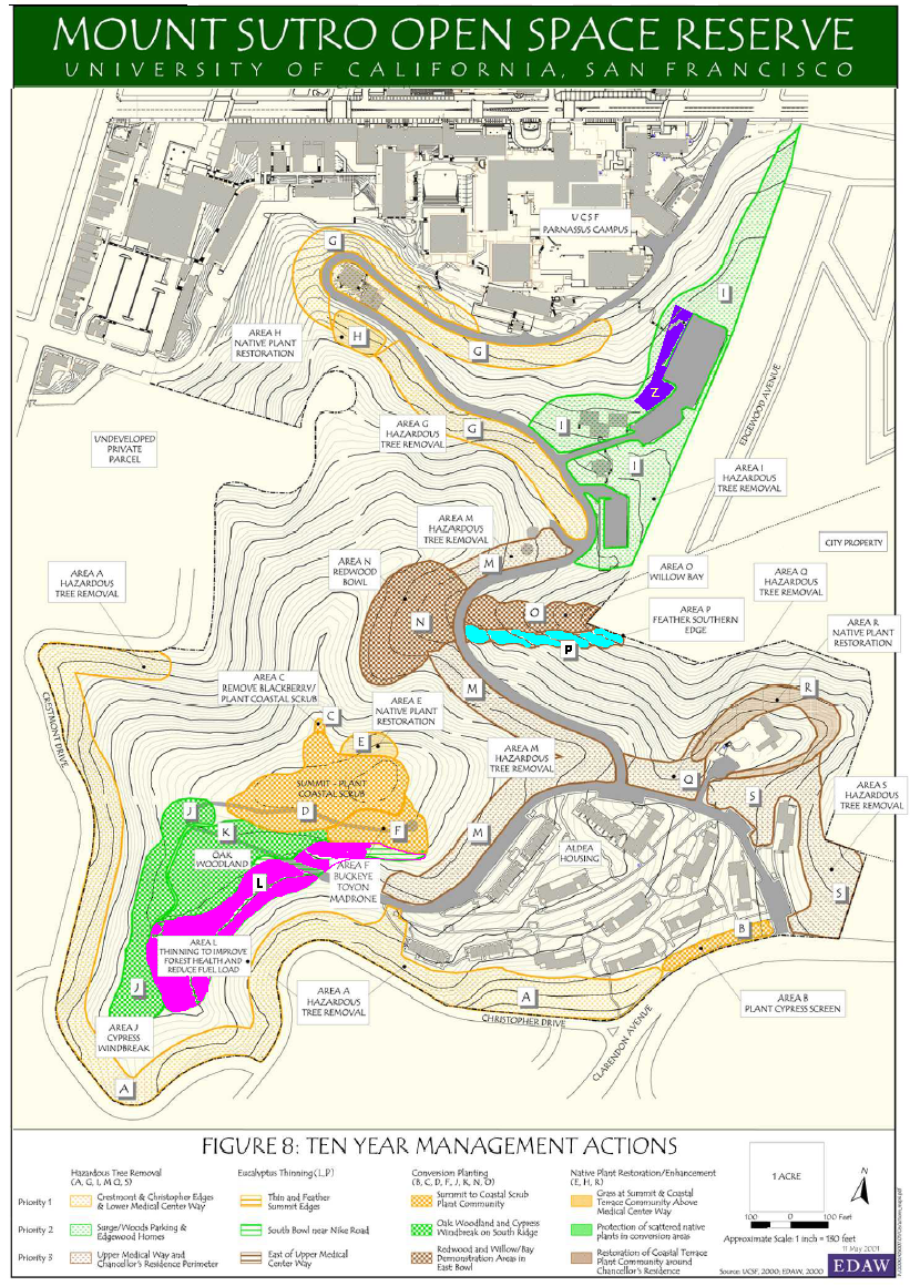
Q: Mount Sutro Forest is one of the last dense forests left in the city, so we have concerns about any thinning, even in demonstration project area. The “Area L” project on the map will impact the whole forest in that area. Area P runs along a seasonal creek that has a different ecology. We would like to see real ecological study of the forest

A: The demonstration areas are small and will not impact the entire forest. Storms have a greater impact on the forest than a small demonstration thinning project. The purpose of the first demonstrations is to get an idea of the visual and aesthetic impact from within and from outside the forest. The thinning of eucalyptus will be on a priority basis. We will first remove safety hazards, limbs or trees themselves. From there, less healthy trees will be removed, leaving the healthiest trees. The thinning will be done to enhance the vigor of the remaining trees, and we will watch what happens when undergrowth is removed. The forest will regrow, and we may need to thin it again in the coming years. The ecosystem will thrive when there is sunlight on the forest floor. Maintenance will be continuous, not just one time.

[Note: Since this is a Cloud Forest, the ecosystem will be substantially altered if there is sunlight on the forest floor. And obviously ecosystem impacts are one of the things to be demonstrated, as well as effects on other trees – such as increased windthrow when the storms blow through a thinned area and knock down trees that no longer have support.]

Q:  How is the two-acre demonstration spot selected?

A: We want a variety in tree size and spacing, slope and other factors. The areas will be selected as part of of our community workshops.

Q: I am concerned that Area L is visible from my neighborhood.

A:  One of the reasons for choosing that location is that it is far back enough as to not weaken the visual aesthetic, and it is particularly dense.

C:  I agree that Area L just above Forest Knolls probably won’t be visible from off site.
C:  I have no problem with a demonstration area on the South Ridge.

C:  In Area P there is a watershed, and we found an old trail there. It would be a great asset to open this up as watershed. Going out to Clarendon might also be good.

Undergrowth Control and Herbicides

Q:  We would like UCSF to agree not to use herbicides. We prefer to use the black plastic ground-covering method. Why is UCSF still using herbicides? Would like to see none used.

A:  That’s a good topic to cover extensively at our next workshop.

C:  I support trying to avoid herbicides, but we should demonstrate which works best regarding cost and efficacy. It may turn out that light toxins work best.

C: Restoring natural drainage is another reason to avoid poison.

C: We can’t convert those who want all native plants and need to acknowledge that things will grow where the undergrowth is cut.

C:  This effort, like the 2001 Plan, focuses on diversity; native and non-native species can co-exist.

Future of the Reserve

Q:  Can you tell us if UCSF foresees any potential use of the area for buildings or functional structures in the University’s long-term plan?

A: This is a permanent open space reserve designated by the University of California Board of Regents, so there will be no buildings or structures. [Note: Except chain-link fences over concrete pads…]

General Comments

C: Calling Mount Sutro forest a cloud forest is unfair to the history of the entire area. The history of the forest goes back further than the 1940s. Originally the hill was as barren as Twin Peaks, but that said, the forest was planted. Logging in the 1930s cut down up to 95% of the trees. A happy medium is what we are looking for.

[Note: We don’t disagree that it was a barren hill like Twin Peaks 150 years ago. It is a Cloud Forest now. Logging in the 1930s ended with creating fire-hazard conditions.]

C: View corridors enabling views from Sutro are important.

[Note: Or not. One of the beauties of the forest is its sense of seclusion and wildness in the heart of the city.]

Posted in Herbicides, Meetings, Mt Sutro Cloud Forest, Neighborhood impact, UCSF | Tagged , , , , | 2 Comments

Six Reasons Not to Destroy Sutro Forest’s Understory

We have been talking about the destruction of the forest’s understory in several areas. This is not an innocuous activity.  Here are six reasons why:

The Logged Forest, 1934

  1. Creating a fire hazard. We have explained at length that the Cloud Forest, in its naturalized condition, is not a fire hazard because it is constantly damp and green. However, a fire hazard can be created. In the 1930s, when the area was being logged and the timber thinned, such conditions existed, and in fact logging was stopped after a major fire in 1934. Stripping out large areas of understory and duff dries out the forest, and recreates those conditions.
  2. Increasing water runoff. The Sutro Cloud Forest’s duff and understory holds water like a sponge. The runoff from the mountain is a fraction of the runoff from, say, Twin Peaks, where the road runs like a river on rainy days. Removing undergrowth and duff and getting down to the soil increases the runoff and could also increase erosion.
  3. Dry conditions could destabilize the forest. These trees have adapted to increasingly damp conditions as the trees gained height and the understory gained density. Opening it up and drying it out changes these conditions, with unpredictable effects on the forest.
  4. Changing the ecosystem. The forest – the trees, the duff, the understory of blackberry and ivy and other plants, all its plants and animals, are tied together in an ecosystem. Destroying sections of the understory changes this.
  5. Removing nutrient layers. As in many forests, the nutrients are tied up in the vegetation; the actual soil is thin and infertile. Removing vegetation from the mountain removes these nutrients instead of recycling them into the eco-system as happens naturally when leaves fall and bacteria break them down into compost in the duff layer.
  6. Changing the aesthetic experience of the forest. One of the most important characteristics of the Sutro Cloud Forest was its mysterious sense of seclusion, the blocking of the sights of a busy city and the damping of the sounds. This created an atmosphere of isolation, of being in the wild heart of a great forest. Opening it up trivializes this experience to one of being in a park, where people are visible on other trails and the sight and sounds of the city penetrate into the diminished forest.

All of these changes are very significant, especially in an ecosystem as fragile as a Cloud Forest. Making these changes ahead of the Environmental Review (ER)  is not only destructive, it is unconscionable, and could invalidate the ER.

Posted in Environment, Mt Sutro Cloud Forest, Sutro Forest "Fire Risk" | Tagged , , , , , , | 6 Comments

Habitat Destruction in Sutro Forest

We posted recently about the destruction of the forest understory along the South Ridge trail, near where it meets the Nike Rd. Now we hear that this isn’t the only area where habitat has been destroyed along the trail. Areas where the understory was 5-6 feet high have been mowed down to a shoulder broad enough to park a car on. And when we checked the UCSF Mt Sutro website, there it was: “Regular maintenance of the trails includes: maintenance to better allow usage and ensure continued accessibility, including keeping a clearance of up to 5 feet on both sides…” Assuming that the trail itself is about 3-5 feet wide, we’re talking about a road that’s up to 15 feet across.

We’re dismayed. This is not “maintenance,” this is habitat destruction.

Habitat destruction ahead of the base-line Environmental Review risks invalidating the exercise. This kind of disturbance of the forest ecosystem will have the effect of reducing populations of birds, insects,  possibly mammals, and existing plant species. It could also change the conditions in those areas of the forest.

The same trail before

(Photo credit http://www.mi9.com )

Moreover, this is still the bird nesting season (which normally continues through June). Given this year’s wet spring, it’s entirely possible that the season has been delayed or extended this year, or that birds are able to raise second broods due to food availability. (Hummingbirds have been known to nest as early as February and as late as June. Click here for a picture of a hummer’s nest on a San Francisco blackberry bush.) Did anyone carefully inspect the bushes before mowing them down?

A fifteen-foot wide unpaved road through trees with thinned underbrush is an altogether different experience than mysterious narrow trails through a dense woodland. “It seems cut back and thinner every time I go up there,” said a neighbor.

We call on UCSF to exercise caution in its forest management. Issues cannot be defined away by declaring understory removal as “maintenance” and chain link fence over concrete as part of the Open Space Reserve.

White-crowned sparrow on blackberry: David Parsons

Posted in Environment, Mt Sutro Cloud Forest, Neighborhood impact, UCSF | Tagged , , , , | 7 Comments

The 1976 UC Regents’ Resolution

As promised, Barbara Bagot-Lopez of UCSF sent us a link to the 1976 resolution by the UC Regents. Most of it pertains to housing on Third Avenue, but it also makes the Open Space Reserve Permanent. For your convenience, we are reproducing it here. (The emphasis added is ours.)

We should also mention that Kevin Beauchamp of UCSF, who made a presentation in February 2010 regarding the new Long Range Development Plan (2012 to 2030), mentioned that the space limit laid down in point 2 has been exceeded, particularly with the new Regenerative Medicine Building coming up.

———————————————–

APPENDIX F: 1976 REGENTS’ RESOLUTION

“DESIGNATION OF OPEN SPACE RESERVE, ALTERATION OF CAMPUS BOUNDARIES, COMMITMENT OF HOUSES TO RESIDENTIAL USE, AUTHORIZATION TO NEGOTIATE SALE OF PROPERTIES AND COMMITMENT OF TRANSPORTATION STUDIES.”

The following recommendations were approved by the Board of Regents on May 21, 1976:

1. That the reserve on Mount Sutro, which was designated as open space for a twenty-five year period by The Regents in October, 1975, be increased from fifty-two to approximately fifty-eight acres, and that the designation be made permanent.

2. That the boundaries of the San Francisco campus be altered to exclude properties on the west side of Third Avenue from 1309-11 Third Avenue to and including 1379 Third Avenue, and that the new boundaries be made permanent. The total structures within the campus boundaries shall not exceed 3.55 million gross square feet (not including space committed to residential use on Third, Fourth, Fifth and Parnassus Avenues and Kirkham and Irving Streets) and this limit shall be permanent. These restrictions prohibit expansion by UCSF by purchase or condemnation or gift of any property or lease of private residential property not only contiguous with the new campus boundaries, but anywhere within the surrounding area bounded by Golden Gate Park, Oak Street, Ninth Avenue, Clayton and Clarendon. This does not prohibit the use of commercial properties or the affiliation with other public agencies within the area described.

3. That the Regents redefine their commitment, made as part of the October, 1975, approval of the Long Range Development Plan, to return certain existing houses to residential use as alternative campus space and funds for rehabilitation and relocation become available for the activities now housed therein, and that as part of this commitment: The ten houses on Third Avenue, outside the campus boundaries revised as recommended in 2. above, be sold subject to the provisions set forth in 4. below; the thirty-four houses on Third, Fifth, and Parnassus Avenues and on Irving and Kirkham Streets be rehabilitated as required and leased for residential purposes, with priority given to University students, faculty, and staff; and the seven houses on Fourth Avenue remaining after clearance of the site for the School of Dentistry Building project be retained for non-residential campus use.

4. That the Treasurer be authorized to negotiate the sale of the lots and structures, and other improvements thereon, located at 1309-11, 1319, 1325, 1337, 1343, 1355, 1361-63, 1367-69, 1373, and 1379 Third Avenue; the lot between 1355 and 1343 Third Avenue; and the lot between 1309-11 and 1319 Third Avenue, subject to the provisions listed in 4(a) through 4(e) below and that the results of said negotiations be presented to The Regents for final approval and authority to sell based on offers acceptable to The Regents:

(a) The offer for sale of the two vacant lots shall commence within six months and the offer for sale of all remaining properties shall commence within thirty-six months, except that no relocation of University activities or tenants or conversion of houses for residential uses shall be initiated until funds for such purpose are on hand as specified in 4(b) below and until space into which activities or tenants can be relocated is available;

(b) A special fund shall be established to fund projects within the Capital Improvement Program for the purpose of, first, providing accommodation for activities displaced by sale of houses, second, providing accommodation for campus activities displaced by conversion of the structures retained for residential use, and, third, converting and rehabilitating the structures retained for residential use, said fund to be funded from proceeds of the sale of the properties, except as noted in 4(c) below, and, if funds are not on hand from the sale of properties, from an advance, as needed, of not to exceed $50,000 from the University Opportunity Fund, such advance to be on a revolving basis and to be repaid with proceeds, as received, from subsequent sale of properties, it being understood that, at the completion of the sale of the properties, any part of the advance not repaid shall be converted to an appropriation;

(c) The portions of the proceeds of the sales of the lots between 1309-11 and 1319, and between 1343 and 1355 Third Avenue, attributable to the eighteen parking spaces currently located thereon, shall be deposited in the Net Revenue Account of the University of California Parking System;

(d) Funds not to exceed $10,000 shall be allocated by the President obtain an appraisal of market value of the properties for use as residences; and

(e) All properties shall be sold in the then existing condition, it being made clear to the buyer that he or she may be required to conform to all applicable State and City and County of San Francisco codes in converting the structures to residential use;

5. That funds not to exceed $25,000 be allocated to the San Francisco campus from the University Opportunity Fund for the purpose of retaining an independent consultant firm to develop additional plans for the alleviation of transportation problems such as traffic, parking congestion, and availability of public transit, it being the intent that such plans be implemented to the extend feasible within resources normally available to the campus for such purposes or within additional State appropriations that might be made available for such purposes;

6. That the Long Range Development Plan for the San Francisco campus, as approved by The Regents in October, 1975, be amended to reflect the described changes in designation of open space, boundaries, and use of housing;

7. That The Regents recognize the principle that the San Francisco campus will be administered so that the annual average of the daily campus population at the Parnassus site will remain substantially in accordance with the projections set forth in the Environmental Impact Report related to the Long Range Development Plan for the campus, approved by The Regents in October 1975.

Posted in Mt Sutro Cloud Forest, UCSF | Tagged , , | 1 Comment

Sutro Forest Updates

We were up in the forest this evening for a bit. Here’s what we saw:

Chainlink fence

1. The Chain link fence on Pad#4 in the Aldea campus has been erected, complete with the three gates promised (one is big enough to drive a truck through). It looks even worse than it sounds. There is no way that can be considered “Open Space” and it would take some imagination to consider that part of the Open Space Reserve, as UCSF intends.  A parking lot is more open and scenic. Unless parking lots are considered Open Space under the agreement?

2. The South Ridge Trail has been substantially broadened for some distance near where it connects to Nike Rd. The understory has been mown down on either side of the trail, so now it’s about 15 feet broad. You could drive a truck on it. It looks as though someone might have done just that. The understory here used to be dense bushes up to shoulder height and it was always full of birds. We hope this isn’t going to continue; it could have a severe impact on the forest ecosystem before the baseline study has been made. [ETA: More detail in this post.]

3. The signposts have been erected. So far, we haven’t seen any graffiti on them, though there’s some on the UCSF property notices in the forest . They are neat and tasteful on brown posts that blend in reasonably well.

Posted in Mt Sutro Cloud Forest, Neighborhood impact, UCSF | Tagged , , , | 1 Comment