
When UCSF (or SF Recreation and Parks Department) discusses “Safety” in the forests on Mt Sutro and Mt Davidson, they generally focus on fire hazard (relatively low in these damp cloud forests), or on the risk of being hit by a falling tree (about half the risk of being hit by lightning). Tree removal could actually increase both those risks, by drying out the forest and by increasing windthrow – the risk of the remaining trees being blown over.
But what we want to talk about in this post is landslide risk.
Two weeks ago, a horrible mudslide in Washington State engulfed homes and took lives. Some scientists think logging trees in the area contributed to the tragedy. This has implications for Sutro Forest, which grows on a steep hill – and also for the other San Francisco forest, Mount Davidson. Tree removal, ongoing and planned, could destabilize the mountainsides.
 LOGGING AND LANDSLIDES
On March 22, 2014, a huge landslide destroyed the small Washington community of Oso. Rain was of course a factor, as was erosion at the base of the slope. But it’s probable that tree-cutting above the slide area was an important factor too. An article in the Seattle Times that quotes a report from Lee Benda, a University of Washington geologist. It said tree removal could increase soil water “on the order of 20 to 35 percent” — and that the impact could last 16-27 years, until new trees matured. Benda looked at past slides on the hill and found they occurred within five to 10 years of harvests [i.e. felling trees for timber].
There had been red flags before. The area was second growth forest, grown back from logging in the 1920s/30s. Over 300 acres were again logged in the late 1980s.
- The first time regulators tried to stop logging on the hill was in 1988. But the owner of the timber successfully argued that measures could be taken to mitigate the risk. Eventually, the state only blocked it from logging some 48 acres, and the owners gave in on that.
- In 2004, new owners applied to cut 15 acres; when the Department of Natural Resources (DNR) objected, they halved the area and re-located the cut. DNR gave approval, subject to no work during heavy rain and for a day afterward. The tree-cutting finished in August 2005.
- In January 2006, there was a major landslide 600 feet from the cut zone. The state built a log wall to shore up the slope.
- The owners continued logging. In 2009, they removed 20% of the trees. In 2011, they removed another 15%. In 2014, the hillside collapsed.
The regulators were aware of the risk; they thought they were mitigating it with their restrictions and reaching a compromise with the owners. But it wasn’t enough. Destabilizing the mountainside is a long-term thing; the effects can show up in months, but it’s more likely to take years.
THE LESSON FOR SAN FRANCISCO
We know our hills are prone to slides. Here’s a geological map of Mt Sutro and surrounding areas. The blue zones show where there’s a potential landslide risk:
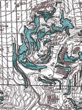
Blue areas show “potential for permanent ground displacements…”
This next map is from a UCSF document. The pink areas and wiggly arrows indicate landslide risk. The double-arrows show where actual landslides seem to have occurred in the past.
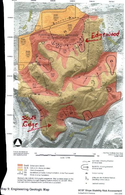
Pink areas and wiggly arrows show landslide risk; double line arrows show past landslides.
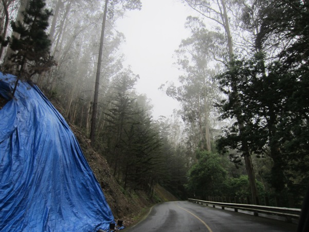
Landslide under blue tarp. South Ridge at top left.
This slope in the Forest Knolls neighborhood was covered in a blue tarp for months after the slope became destabilized by tree removal…
This other blue tarp is on the hillside above Medical Center Way. It was installed soon after some extensive work on the trail in that area, with undergrowth being cleared and trails realigned. When we enquired why it was there, UCSF said there had been some rock slides, and this was a temporary solution.
This photograph was taken in March 2013. A year later, the blue tarp is still there.
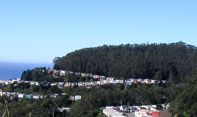
 For more evidence, there’s the ongoing situation in Twin Peaks, where erosion and rockfalls in rainy weather are ongoing. There, it matters less, because it’s not falling on homes. Landslides on Mt Sutro or Mt Davidson have the potential to damage homes.
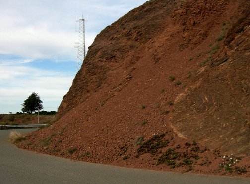
rockslide
YEARS OF INCREASED RISK
While it’s possible that a slide could happen within months of the tree-felling, it could also happen 6-8 years later as the root systems rot away. It could happen in any year until the trees grow back and conditions are right for water-logging. On that fateful Washington slope, the average was 5-10 years. No one wants to find out the average for San Francisco slopes.
We ask the land managers for these forests to stop removing trees and large shrubs that have successfully stabilized our hillsides for decades.


One would think they’d realize this by now. This is a good post and may the tree-felling nativists out there finally start to wake up and smell the eucalyptus — and realize the harm they could cause by this silly trend. Ahhhhh, the forests after a good rain!
Several years ago, the National Park Service removed the trees from above the cliff on the west side of the Presidio NP. Just one year ago after a single rain from that year’s past “rainy” season a rock slide occurred that was so extensive that it threatened to undermine the road along the top of the cliff. This slide was predictable. More in the same area may occur especially when this drought is broken. The natural plant [people] either don’t understand the concept or they don’t care. The amount of damage that could result from removing the trees on these 2 peaks is at least as great as any fire even if the peaks weren’t moist environments.
This has to be about as stupid as it can get. Leave the trees alone. What is this going to do to the area in the event of a mud slide? What is going to hold the hills intact?
Pingback: Sutro Forest: Risk and Uncertainty | Save Mount Sutro Forest