Of late, your webmaster has been carrying on an interesting and detailed debate on the neighborhood site Nextdoor about fire hazard. The other person involved opposes our position, and has been willing to discuss it. We appreciate that; we believe that talking to people with a different point of view is important.
JAKE SIGG’S ALLEGATION
Yesterday, Jake Sigg’s newsletter published a post from our opponent (we follow Mr Sigg’s lead in not naming him) regarding CalFire’s assessment of risk in San Francisco. In that, he [i.e., Mr Sigg] included an allegation:
“SF Forest Alliance/sutroforest.com has been known for selective quotations that alter or reverse what writers intended. We have all learned to question authority and to insist on transparency. SFFA/sutroforest.com needs to become transparent in its messages. Its withholding of the complete opinion of Cal-Fire deprives the public of the information it needs to protect itself. In keeping with that you will find the complete letter at the bottom of this newsletter, sans author ID.”
OBJECTION!
So let us object here. We do not – and would never – “alter or reverse” what writers intended. We stand for transparency, and try as far as we can to include references so people can go back and look at sources if they wish.
Nor have we withheld “the complete opinion of CalFire.” In fact, what we have quoted of CalFire is taken from two sources that readers may verify:
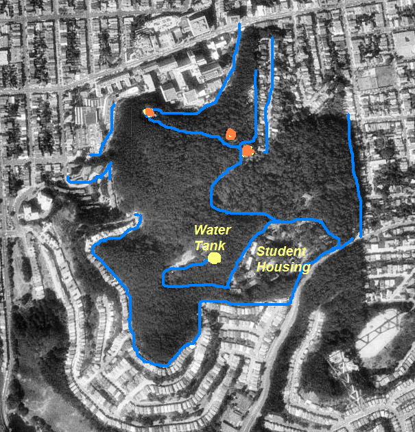
(1) The CalFire website, which we linked when we mentioned it. That is where we obtained this map, which shows that CalFire gives its lowest hazard rating to Sutro Forest (and most of San Francisco).

CAL FIRE map shows Mt Sutro Forest has the lowest level of fire hazard (gray color indicates areas not rated – mainly built areas). The blue and pink pointer lines added by us.
We provide that link again here: CalFire Hazard Map.
We also referred to the page on the CalFire website, where in an update it said:
“Update, 11/2008:
CAL FIRE has determined that this county has no Very High Fire Hazard Severity Zones (VHFHSZ) in LRA [Local Responsibility Area]. Therefore this county will not have a map of recommended VHFHSZ in LRA.”
That link is HERE.
(2) A letter from FEMA to Cal EMA regarding UCSF’s request for funding to cut down trees on Mount Sutro.
We did indeed post an excerpt from that, given below.
 We do not think that “alters or reverses” the intent of the letter. But if someone wants to verify this, the full letter is here, in two parts:
Mt Sutro PDM – Letter from FEMA – Environmental-Pt 1
Mt Sutro PDM – Letter from FEMA – Environmental-Pt 2
And if they would further verify that this indeed is the letter – it is available to anyone who requests it under the Freedom of Information Act from FEMA, and as Public Records Information from UCSF.
SO IS WHAT CALFIRE SAID DIFFERENT?
We think that what we’re seeing is different conclusions reached by our opponent and ourselves.
What CalFire explained to FEMA, and to our opponent, is that fire has two factors: Fuel Rank, and Rotation Rank (or the risk of ignition). Fuel rank is only density of vegetation, and we, UCSF, and our opponent all agree that the vegetation density in Mount Sutro Forest is high.
The second factor is the risk of ignition, and that is low in most of San Francisco. (The CalFire map above shows a little orange spot on the edge of San Mateo County that has High – but not Very High risk.) San Francisco’s climate is cool and not extreme. Right now, while the rest of the country has a heat wave, the fog blows through our city.
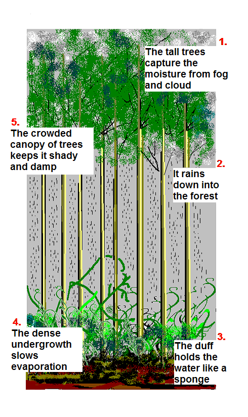 Ignition risk is particularly low in Mount Sutro Forest, which lies directly in the city’s fog belt. The Cloud Forest effect increases moisture levels considerably as the trees harvest moisture from the fog, and store it in the dense understory. It’s obvious that the best way to keep ignition risk low is to trap that moisture and reduce evaporation.
We are unsure whether the recommendations discussed there come from our opponent, or from an individual within CalFire. (It does not appear on the CalFire website.)
We hope to make our own contact with that organization, and if we do, we will write about it here.
WHY THE UCSF PLAN IS COUNTERPRODUCTIVE
Even if the Plan reduced the Fuel Rank (and we don’t see how it would, given that the Plan would be to fell the trees and leave them there as logs and chips), it would raise the ignition risk by drying out the forest, reducing both harvested and retained moisture, and by increasing wind velocities in this very windy part of San Francisco.
FEMA had similar questions for UCSF. This is again a quote from the same letter cited above.
 We don’t think this is a good trade-off, especially since this is not a distant wild-land, but in the midst of the city with access to water sources and fire-fighting capability.
 There is actually a fire-station on the Stanyan side of the forest, a fact that was cited during the hearing about opening the trail from Stanyan into the forest through SF RPD’s Interior Greenbelt. At that meeting, Ray Moritz (who was also hired by UCSF separately) allayed neighbors’ concerns about increased ignition risk from such a trail by saying that overall risk was low. The report of that meeting, written from contemporaneous notes, is HERE.
We don’t think a model based on increasing ignition risk while reducing fuel is workable for this site. And aside from the environmental damage this “solution” would cause, in reduced carbon sequestration, poorer pollution control, potential hillside destabilization, increased water run-off, lost habitat, and use of substantial amounts of toxic pesticides – this is not reversible in the short or medium term. If we discover it’s all a horrible mistake, it cannot be undone once the trees lie on the ground as logs and chips.