
ABC7 television had a 2-minute piece on Sutro Forest recently.

Click on the picture to go to the ABC7 video
We think it’s great coverage, and ABC7 is doing the community a service by getting this issue out there.
But we’re concerned about how two interviewees focused on fire hazard, which has been exaggerated.

Right now, the forest, which lies squarely in the Fog Belt, is a Cloud Forest – meaning it’s wet year around. It captures 30-40% of its moisture from the fog, and traps it in its dense understory. Save Sutro kept a “Fog Log” in the dry year of 2009, and found the longest dry spell was – 7 days. (A dry spell was defined as an unbroken string of days when the forest got moisture from neither rain nor fog.) In UCSF’s own 2001 report, it mentions “up to ten days in the autumn.” At a public hearing to open the Stanyan Trail, we heard from Ray Moritz, UCSF’s hired arborist, speaking as a fire ecologist. He said the fire hazard was low. The greatest danger, he suggested was when people did not clear debris from the roof area around fireplace chimneys.
Ms Noyola, who was interviewed together with Dr Morley Singer, and Ms Barbara Bagot Lopez (of UCSF’s Community Relations), lives beside the Interior Greenbelt, the city-owned part of the forest. (She also spoke at UCSF’s Feb 25th public hearing.)
We’re not sure if she recognizes that UCSF’s Plan will actually raise the fire hazard.
CREATING A FIRE HAZARD
“Thinning” the forest will make it drier and windier, thus increasing the fire hazard. Consider the statement of Dr Mascaro, who is a professional ecologist: “By thinning the forest and removing most of the understory vegetation, the management activity will open the canopy of the forest resulting in drier and hotter duff on the forest floor and a greater risk of fire.”
In fact, we think it will be even worse. Removing thousands of trees and tearing gaps in the canopy will reduce the amount of moisture captured in the first place. Then, with no shaded understory (since more sunlight is reaching the forest floor and 90% of the understory removed), there’s nothing to retard evaporation.
The picture below (from the Interior Greenbelt part of the forest) is an example of what might be expected.

 The DEIR says it’s the South-facing slopes that are warmer and drier, but in fact it’s the open areas on the east side that are dry now – while the trails up the South side are quite damp. You can see evidence of this drying on the new trail from Stanyan, where 50 trees were cut along the trail, thus opening huge gaps in the canopy. A lot of understory was also removed. The forest is visibly drier there than in the more enclosed parts. A walk along the Historic Trail illustrates this as well – the path can change from dry dust to damp earth within a few inches, depending on the state of the forest. If the whole forest is made as dry and dusty as these areas, by removing thousands of trees and nearly all the understory, the hazard could increase.
In addition, the Plan calls for cutting vines to 10 feet above the ground. This is going to leave the few remaining trees festooned with dead vines which are supposed to dry up and blow away, but actually dry up and remain for years. We wrote about that back when the Community meetings were in progress, here: Creating a Fire Ladder?
WATER AND ROADS IN THIS FOREST
In any case, there are other options. Water lines run to the summit of the mountain, and there’s a water tank within a few yards of it. Water is supplied to the Aldea campus, and to the office buildings along Medical Center Way. Fire trucks can access most of the forest either from paved roads surround it, or from the paved Nike Road to the summit of the mountain. The blue lines on the map below indicate paved roads. The yellow dot is the water tank close to the summit (which has water pipes and has even been irrigated). The orange spots are office buildings, which would have a water supply.
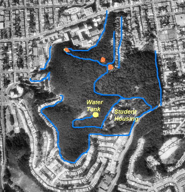 Even though the forest gives a feeling of seclusion and entering another world – it’s actually quite accessible. If there’s a dry spell, it would be cheaper and less destructive to bring in a tanker to just spray the forest once or even twice.
The least accessible portion – the western slopes overlooking the Inner Sunset – is in fact the 15 acre part that won’t be thinned under the UCSF Plan.
THE “FIRE HAZARD” STORY
It’s not fair, though, to blame those who do fear fire. UCSF has been talking up the fire hazard at least since 2009, when it applied for a grant from FEMA to reduce fire hazard by cutting down most of the trees on 14 acres of the forest: 8 acres on the South Ridge (around Demonstration Area #1) and 6 acres behind Edgewood (around Demonstration Area #2). FEMA came back with a lot of questions that UCSF couldn’t answer. Instead, UCSF withdrew its application.
FEMA noted that UCSF “inaccurately interprets a map”, “provides inadequate details regarding the history of wildfires in Sutro Forest, and provides a simplistic and ineffective comparison of the wildfire hazard in the Sutro Forest to the hazard in other areas that have burned in the San Francisco Bay area.”
It notes that the CALFIRE map is the relevant one, and that shows the forest to be a “moderate” fire hazard – the lowest rating of the three that CALFIRE assigns.
 Now, quite surprisingly, the DEIR still uses the same maps that FEMA found it “inaccurately interprets” – and it still inaccurately interprets them in the same way. (The whole “map” story, for anyone who wants that level of detail, is HERE.)
The DEIR also suggests that the CALFIRE map is “a draft” and could change, though it was prepared in 2007 and a note on its website affirmed, in November 2008, that our city and county had no areas of Very High Fire Hazard areas: “Update, 11/2008: CAL FIRE has determined that this county has no Very High Fire Hazard Severity Zones in LRA [Local Responsibility Area]. ” That covers Mount Sutro Forest. Clearly, in CALFIRE’s assessment, there is no Very High Fire Hazard. (Meanwhile, the maps that UCSF “inaccurately interprets” were prepared in 2004 and 2005.)

CAL FIRE map shows Mt Sutro Forest has the lowest level of fire hazard (gray color indicates areas not rated – mainly built areas)
ERRONEOUS COMPARISONS
It also continues to make the same simplistic comparisons to fires elsewhere: the fires in Oakland and on Angel Island.
In fact, both Angel Island and the Oakland fire are counter-examples. Angel Island was covered with eucalyptus trees for decades. During that time, the only reference we could find to fire was a fire in a building. Since the trees were removed, there have been a number of fires, culminating in the huge October 2008 fire. It burned the grass and shrubs over half the island, and stopped at the tree-line.
The Oakland fire also started with shrubs and grasses. It spread to trees and buildings, but the trees were victims of the fire, not the cause of it. The main fire spread from house to house. A report on that fire, from David Maloney who was on the investigative task force, is HERE. It also clarifies that eucalyptus is not particularly flammable.
The weather conditions in Oakland and on Angel Island are also have drier and more extreme weather than San Francisco’s Fog Belt. Besides, Sutro Forest’s uniquely wet micro-climate is not comparable – though ironically, once the forest has been thinned and dried out, the comparisons might be closer. Nevertheless, San Francisco’s climate remains much less extreme than either place – cooler (and wetter, with the fog) in summer; and warmer in winter.
To everyone who is concerned about the fire hazard: Ask UCSF and the Sutro Stewards (the volunteers who actually manage the forest) to maintain it as a functional cloud forest.
- Stop tearing out understory unless its actually to maintain trails.
- Avoid cutting down trees unless they are actually hazardous, not just because they are in poor condition.
- Build the trails to channel water across them to the downslope side, and maintain the dense vegetation on either side. That way, the areas that aren’t actually trail will remain damp, and the vegetation will help remove moisture from the trail.
- Ask UCSF to put in place a sensible emergency plan for any situations where the forest – very rarely – does get dry.


I have never once heard of the Sutro Forest catching fire, so why is this an issue all of a sudden? And such an emergent one? Why doesn’t anyone bring this up? We just don’t get forest fires in San Francisco. House fires, definitely. Forest fires, never!
[Webmaster: There were a few… but the large fires date back to when it was barely a forest – during Adolph Sutro’s lifetime. There were also some fires when the forest was opened up by logging. We can’t understand why the Plan wants to recreate that situation. They seem to have a fundamental misunderstanding about how this forest works and what it is. We’ve found the UCSF people hardly visit the forest. They work and live elsewhere. Except for the Chancellor (who actually lives in the forest) and she seems reluctant to be involved.]
SMSF & Gina -good day – thanks for keeping us all posted on Sutro Forest “:discussion”.
1) Please check Westside Observer (Page 1 Forest Knolls situation on backside of Sutro), and pages 15 & 16 re: Sutro Forest article, and great old picture . http://www.westsideobserver.com/pages/page1.html
2) also, please check March 2013 Miraloma Life http://www.miralomapark.org/
for articles on MT Davidson trees and Sutro Forest Miraloma Life Online – March 2013
• PDF Version – March Miraloma Life • MPIC All-Ages Neighborhood Networking Event: March 9, 2 to 4 pm • From the President’s Corner • The MPIC’s Position on the Plans for Mt. Davidson Forest • Preserving or Destroying the Mt. Davidson Forest? • Mt. Davidson’s Forest—the Discussion Continues • Another SF Forest at Risk?*
keep up the pressure Phillip
Pingback: Sutro Stewards: The Good, The Bad, and the… ??? | Save Mount Sutro Forest