
 We were not aware of the existence of the “Parnassus CAG Action Team” – a sub-committee of the UCSF Community Advisory Group (CAG) – until now. This meeting was run by Craig Dawson (Mt Sutro Stewards) and Kevin Hart, a CAG member living on 5th Avenue.
[ETA3: The legal letter informs us that UCSF sponsored this meeting:
 So, we would like to clarify: though the agenda for the Parnassus CAG Action Team Community Meeting said that Craig Dawson and Kevin Hart were co-facilitators, it was only sponsored by UCSF.]
The Agenda items that were directly of interest to Forest Knolls/ Sutro Forest:
[ETA4: We had a map here showing the planned trail, modified from what we believe is a non-copyright map circulated by Rec & Parks as part of a public memo.
As demanded by the letter from lawyers for Sutro Stewards and SF Parks Trust, I have taken down the map. I hope to replace it later with another providing the same information. Edited to Add, Feb 2013: Here, below.]
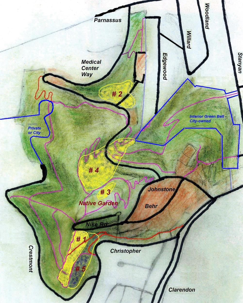
1. Clarendon Connector Trail. There is still a plan to punch a trail to Clarendon through the screen of trees that lies between Christopher and the Aldea campus. (The blue line above Christopher Drive in the map below.) [Edited to add, Feb 2013: The brown line just above Christopher in the map above.] We protested that the screen had already been thinned by the actions of SFWD: The Gash had been cut through to the water tank; and all the trees removed behind the new Pump Station. Putting a trail through it would be meaningless and counterproductive.
The justifications used were confusing.
- The first was to route trails away from the UCSF campus. But the alternative is for hikers to just walk along Christopher Drive for a few yards, it doesn’t go into the campus. Second, two trails already originate on the campus: The Fairy Gates trail starts right outside the Chancellor’s House; and the East Ridge trail opposite the new Community Center. There’s no plan to close off those.
- The second justification is that it brings hikers closer to the highest point of Clarendon Avenue, where it’s safest to cross the street to the trails on the other side (
marked “Safe” in red on the map[ETA Correction: The “safe” point is not the crest of the hill; it’s where the road narrows and there’s good visibility.]). But it doesn’t do that either. It only brings hikers to the same place they’d get to from Christopher. And if the comparison is with Johnstone (marked “Clarendon Access” in the map above) — that’s actually closer to the Safe point.
Craig Dawson claimed they would plant the sides of the trail to conceal it from the houses along the road. We are unsure about this; the “screen plantings” meant to screen the Aldea campus from Clarendon have not been very successful, and the chain link fence remains visible there. Craig also said the perception of thinning — apart from the area around the pump station, and the pipeline Gash — was because ivy had been removed from all the eucalyptus trees. (He noted that his mother lives on Christopher Drive.)
2. The Community Center (to be called The Aldea Center) apparently is going to be used by Aldea tenants, the University Community, and to a lesser extent by Neighborhood groups in addition to the Mount Sutro Stewards. A few parking spaces will be associated with it; but the main access is expected to be by Shuttle bus or hiking in. It is expected to be ready by this summer.

3. The Native Plant Nursery (now called the Aldea Seed Propagation area) is planned to go ahead; the idea is to grow plants for the Native Plant Garden at the summit, and maybe for other locations. This is the pad surrounded by chainlink on the Aldea campus. Apparently the legal department has given the opinion that since no permanent structure is planned, it can be made part of the Open Space Reserve. We’re a bit puzzled by this. Are car parks also open space by this reckoning?
On the matter of “planted to blend in with the forest” as promised in an agreement with the community in January 2000 and reiterated in August 2009 — Maric Munn said there are no plans at present to do that, but the present use doesn’t prevent it in the future. They also repeated the point about slope stability if the retaining wall was removed. (We had asked for the report on this; I repeated that request.) [Edited to Add, Feb 2013: We never received this report.]
4. Bulletin Boards. Two bulletin boards, with maps and rules, are to be posted somewhere in the forest (not on the campus as originally discussed at the Agenda Planning meeting). One may be at the summit; another possibly on the historic trail.
5. Bike cage. A new bike cage is to be built outside Milberry Union, to provide bike commuters with safe storage. Three trees in the area will be preserved. UCSF has a $50K grant for this from SFMTA, and will match it with $50K of its own; vines will be grown over the front to improve its appearance.
6. The 68,500 square foot Regenerative Medicine Building (Stem Cell Research building) at the bottom of Medical Center Way is nearly ready; move-in could be in a week. It has a green roof, currently grass, but may be landscaped with other plants later. This building will have 250 people working there.
It got a Mitigated Negative Declaration on its environmental impact report on the basis that an old building, University Hall, would be demolished – but that hasn’t happened. So the mitigation didn’t occur. UCSF has a 3.65 million square foot space ceiling for Parnassus; it was already 4% over this, with a plan to reduce that excess to 2%. Instead, 6% over. This will have to be resolved in the new Long Range Development Plan, which will run to 2030.
Someone asked if it wouldn’t have been cheaper to build it at Mission Bay. Apparently, owing to all the other facilities concentrated at Parnassus (which would then need duplicating at Mission Bay), the cost is approximately the same.
———
Though many present were associated with the Mount Sutro Stewards, some neighbors from the other sides (Inner Sunset, Woodside Road) were also present. Concerns:
Traffic and congestion on Parnassus. Despite meetings and discussions and decisions, nothing had been implemented. Someone pointed out that unresolved issues remained from all the previous discussions and should not just be rolled over into the new Long Range Development Plan (to run to 2030).
Tree felling on Stanyan in connection with the Historic Trail opening. A number of trees have been cut down. Craig Dawson pointed out this was Rec and Park responsibility, and thought it might be in response to neighbors’ concerns about hazardous trees, expressed at meetings about the Historic Trail. [Edited to Add: We went to take a look. That report is here.] [Edited to Add 2: He also mentioned that in the course of trail building in the UCSF portion of the forest only one tree, which overhung the trail, had been removed.]
UCSF, plans, and the Long Range Development Plan. This is about to start now; the next meeting of the Community Advisory Group is on November 29th at 6.30 p.m. at Milberry Union.
WHAT HAPPENS WHEN UCSF CHANGES ITS MIND?
One thing confused us: What happens when UCSF changes its mind or just doesn’t do what was agreed?
There were at least two clear instances, possibly three. The largest was in the matter of the Regenerative Medicine Building, and the space ceiling (with the number of people and the extra traffic implied). Then there was the Plant nursery, set up where the agreement was planting to “blend in with the forest.” Traffic management on Parnassus may have been a third.
It seems at present the answer is, Nothing happens. It just goes ahead.


I’d like to provide some additional info on the crest of Clarendon, since there seems to be some confusion.
The spot marked “safe” on the map above is not the crest of the road. In fact, the high point of Clarendon is at the intersection with Dellbrook, where the map says “be alert crossing road”. Dellbrook also happens to be the access road for the Twin Peaks trail system, so that’s the ideal place to cross the road from the Sutro side. (The spot marked “safe” does not provide access to any existing trails.)
I think the proposed “connector” trail would promote crossing Clarendon near Dellbrook, which would be a good thing for pedestrian safety. Routing folks along Christopher Drive could also achieve this end, although I personally prefer a trail if a reasonable balance can be struck with neighbors’ concerns for privacy & aesthetics.
It should be mentioned that safety-wise the trail is only part of the story. Due to the steepness of Clarendon, the near-blind curve near Dellbrook, and the lack of sidewalk on the south side of the street, entering Dellbrook as a pedestrian is a dangerous proposition no matter how you do it – even at the crest of Clarendon. If this is going to be a throughway for the Bay Area Ridge Trail then we could also do with a crosswalk and/or traffic calming on eastbound Clarendon as it approaches the blind curve. Another alternative is adding sidewalk on the south side of Clarendon near Dellbrook, although that would likely require removal of some parking spaces.
There are no easy answers here. Despite my concerns about safety, I think we need to continue the conversation about the “connector” trail, which is an important piece of the puzzle in the larger trail system. I also think the privacy & aesthetics concerns raised by neighbors are legitimate and ought to be addressed in any solution, including one that uses Christopher itself.
I enjoy the lively discussion at our community meetings and believe that UCSF has done a good job brokering a fair, open process. Making progress is going to require compromise, and I am hopeful that all participants, both the outspoken and the soft-spoken, will keep an open mind as we move forward.
-Dave
Dave is right; the spot marked “safe” is not the crest of the hill and it’s been corrected above. (But it is the narrowest spot with good visibility for traffic.)
I think the suggestion of adding sidewalk on the other side of Clarendon is a valid suggestion that should be considered. My guess is that the proposed trail would probably have to go to Christopher anyway; the space behind the pumping station between it and the Aldea boundary is very narrow.
That said, Clarendon traffic above Panorama isn’t usually heavy except during school drop-off and pick-up times.
As a followup- there is now a trail shortly after the narrowest point, opposite the Aldea Campus on Clarendon Avenue. Several trees have been cut down and the understory cleared. It’s visible from the road.
Pingback: Parnassus Meeting Nov 8th 2010 | Save Mount Sutro Forest
Pingback: A Letter from Lawyers about the Sutro Stewards | Save Mount Sutro Forest
Pingback: Mt Sutro Stewards and the Kill-Trees Trail | Save Mount Sutro Forest
Pingback: UCSF’s Mt Sutro DEIR: How Many Felled Trees – 30,000 or 22,000 or zero? | Save Mount Sutro Forest
Pingback: Sutro Stewards: The Good, The Bad, and the… ??? | Save Mount Sutro Forest