UCSF presented its new Draft Plan for Sutro Forest at the Third Technical Advisory Committee meeting on Aug 18, 2016. This plan will be implemented in three phases: Year 1-5, Year 6-10, and Year 11-20. However, it is heavily front-loaded, with much of it being done in the first five years. The last ten years only continue what was done earlier. The end result is supposed to be a greatly thinned “see-through” forest with open areas between 0.5 and 5 acres in size. The forest will look and feel very different, (though UCSF says it intends to retain the sense of a forest).
 The Plan divides the forest into four areas, each with different characteristics and tree density. Of the four areas, three are characterized as being in “Fair” condition, and the fourth in overall better condition. (That would be the Western side, where the steep slope has discouraged too much interference.) The brown blob in between Type 1 and Type 4 is the Native Plant Garden at the summit
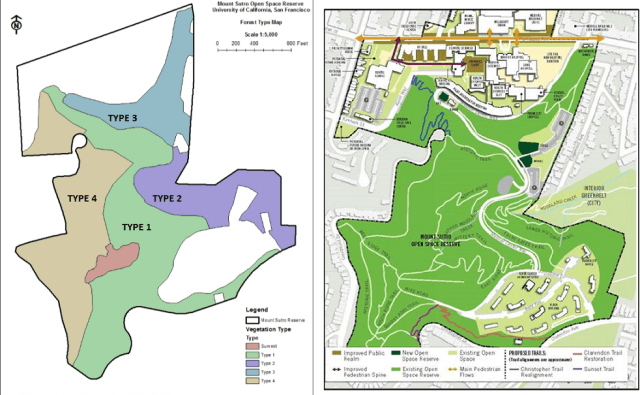
Type 1 is what most people experience as the core of the forest. It has the highest density, at 279 trees per acre, and also the highest number of snags (standing dead trees) that are so valuable to wildlife, about 100 per acre. (See the Trail Map above for comparison.) Type 2 has the least density, with around 45 trees per acre. Type 3 and Type 4 have 110 and 128 trees per acre respectively.
THE PLAN
(See the whole 64-page draft plan HERE: Sutro-Management-Plan-TAC-Draft-081216 )
Phase 1 of the Plan: Initial 5 years (probably 2017-2021)
This phase would cover about 39 acres of the 61 acre forest (or possibly even 57 acres), and would involve extensive removal of trees and understory vegetation (mainly ivy, blackberry).
- Assess trees to 50 feet on either side of the trail (currently they assess 25 feet), and remove those that are dead, dying, or leaning. This would cover 18 acres of the 61 acres of UCSF’s portion of the forest. (There was some talk of expanding this to 100 feet, which would presumably also double the area from 18 to 36 acres.)
- “Forest Treatments” to remove unhealthy and structurally unsound trees, understory plants that would compete with “desired vegetation” (presumably native plants), prevent sprouting from decayed stumps, and planting new trees. Specifically: In two areas of Forest Type 1, clear a total of 1.5 acres and plant about 100 trees per acre. In 8 separate areas in Forest Type 1, clear a total of 2.5 acres and plant blue gum or other eucalyptus species.
- Expand the native plant garden from 2 acres to 5 acres.
- Clear trees within 30 feet of buildings, roads, and neighboring properties as “defensible space.” This would be about 14 acres.
- Widen trails to 5 feet at least, maintain vegetation for 5-10 feet on either side, and keep understory plants below 3 feet in height for visibility.
Phase 2 of the Plan: 6-10 years (probably 2022-2026)
- Remove trees to thin the forest. In Forest Type 1, remove 50-65 trees per acre; in Forest Type 3, remove 20-25 trees per acre; and in Forest Type 4, remove 10-15 trees per acre. Preferentially remove unhealthy and smaller trees (less than 18 inches in diameter at breast height.) Focus removal on non-blue gum trees. [We’re not sure why.] Start with the areas they do not plan to re-forest.
- Treat all the forest types with a tree-planting program, 50% eucalyptus and 50% other species, with a 20 x 20 spacing, looking for around 75 trees per acre surviving. This may be modified depending on slope, water, and sunlight conditions.
- Continue with tree risk management, planting native plants, managing defensible space, and trails.
Phase 3 of the Plan: 11-20 years (probably 2027-2036)
- “Treat” any areas not treated in the first ten years. Continue doing what was done in the first ten years.
Monitoring: The Plan recommends ongoing monitoring. Specifically: checking on the sites the consultants sampled to establish initial conditions every ten years; monitoring “treatment” areas at 1, 3, and 5 years; keep a plant inventory, and ideally an inventory of birds and other wildlife.
TIMELINE TO THE PLAN
Now that the third TAC meeting is over, UCSF’s planned timeline is as follows:
- September: Publish the final Plan
October 4th Tuesday at 6.30 p.m,October 15th Saturday at 2.30 p.m, 2016: Two community meetings to discuss the Plan. (Dates changed to Saturday, October 15. 2:30 p.m. – 4:30 p.m. at Millberry Union, 500 Parnassus Avenue, San Francisco, CA 94122 and Thursday, October 27. 6:30 p.m. – 8:30 p.m. Aldea Center, 155 Johnstone Drive, San Francisco, CA 94131)
- October/ November: Publish initial Study for Environmental Impact Report (EIR).
- November/ December: Scoping Meeting for EIR
- Spring 2017: Draft Environmental Impact Report on the Plan
- Spring 2017: Public hearing on recirculated draft
- Spring/ Summer 2017: Prepare responses to public comments
- Summer 2017: Publish and certify the Environmental Impact Report
- Fall 2017 (after the nesting season): Start implementation.
Mount Sutro Cloud Forest, 2016