This article is slightly modified and republished from a post on forestknolls.info
 UCSF is going ahead with plans to add three new trails to Sutro Forest. While we don’t object to trails as such, they all cost us trees – if not immediately, a year or two later when tree lining the trail are declared hazardous. If they’re not felled to build the trail (as happened with the Kill-Trees Trail), trees are later marked as hazardous and removed. Over 1500 trees have been removed since 2013, with around 350 being felled this last winter.

UCSF map modified to show the three new trails in orange
Also, the entire forest is only 72 acres, divided already by Medical Center Way, a paved and motorable road. Once it’s crisscrossed with trails and the understory torn out, it will lose the seclusion and enchantment that once made entering it like stepping through a portal into some place outside the city. There’s such a thing as too many trails for a 72-acre forest.
The three trails planned are: A new trail on the South Ridge #2 on the map above, in addition to the Quarry Road Trail that was built with no notice to the community. And a long and complicated trail will be built from the northwest side of the forest (#1 on the map above). While access from that side is useful and a benefit to the community, it’s clearly more than needed there. It could easily have ended at the hairpin on Medical Center Way – as the social trail did before it was blocked.
THE CLARENDON CONNECTOR TRAIL
The Clarendon connector trail (#3 in the map above) would run inside the screen of trees that divides Forest Knolls from UCSF’s Aldea Housing. They hope to finish it by November 2016.
This is, coincidentally, the area that was severely thinned in August 2013. (“Before”picture at the top, “after” picture below.) This means that the actual trail probably will cause less destruction than it would have before. This is not necessarily true of the two other trails.
 The Clarendon trail would start on the Clarendon- Christopher corner, go into the narrow alley behind the pump house and fence, and continue on parallel to Christopher. (That’s the orange line on the map below.)

NEW TRAIL HEAD PLANNED
On March 14th 2016, UCSF and the Sutro Stewards had a meeting to design a formal new trail head at Clarendon x Christopher. (The red labels aren’t original to the picture, they’re just to orient you.)
 The initial designs showed a seating area of granite, a kiosk with maps and signs, and gravel. The idea was to provide a well-marked entrance to the forest from the UCSF side (there is already one from the Stanyan side) that would avoid the campus, connect to new trails across Clarendon Avenue being built by San Francisco Recreation and Parks (SFRPD) near Sutro Tower, and have street parking available since UCSF has no plans to provide additional parking for this. They were looking for public input on what they wanted at the Trail Head.
 Some of the ideas – seating, some kind of shelter from the wind that blows up Clarendon, a water-fountain, an earthen berm along the Christopher side to provide wind protection, permeable pavers on the ground instead of gravel.
So far, no funds have been set aside for this. It seems to be a fund-raising opportunity for the Sutro Stewards, who plan to write grant proposals for the money. UCSF may provide some funding too, but it is unclear how much. The team – the Sutro Stewards, and Julie Sutton of UCSF, seemed to want people to think big. Maybe that would justify a bigger grant?
CONNECTING TO OTHER SFRPD TRAILS
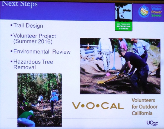
Lisa Wayne of SFRPD attended, to show how the new trail would link to three other trail projects SFRPD is working on: The Creeks-to-Peaks Trail from Glen Canyon to Twin Peaks (already being built); the plan to turn half of the figure 8 on Twin Peaks into a bicycle/ pedestrian area by restricting cars to the other half (in design); and trails to connect Twin Peaks to Mount Sutro via trails past Sutro Tower (yellow dotted line below – in planning).

She’s hoping to get work started this summer, for an opportunity to use VOCAL volunteers. Hope this doesn’t mean cutting down trees in the nesting season. Actually, not cutting down trees at all would be better, but trees are apparently the casualty of every SFRPD project, especially near any “Natural Area.”
CONNECTING TO THE BAY AREA RIDGE TRAIL
Several people from the Bay Area Ridge Trail group came, and Bern Smith spoke about how this new trail would connect to other trails and become part of a 550-mile trail system around the Bay. The Bay Area Ridge Trail actually sounds quite amazing, and we admire the effort and commitment the group has put in to make it happen.

COMMENTS AT THE MEETING
The gallery below shows the comments from people at the meeting – which included a few members of the public, but no neighborhood representatives. If you click on the pictures, they should become legible.


UCSF is taking comments. You can send them to Christine Gasparac: christine.gasparac@ucsf.edu